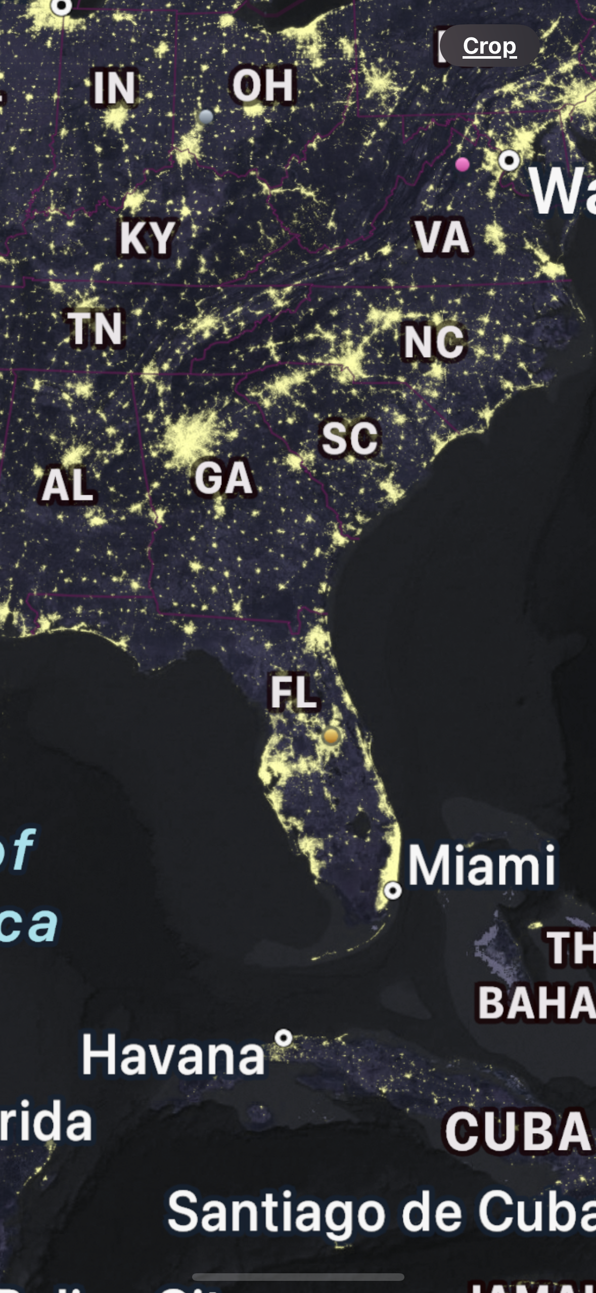
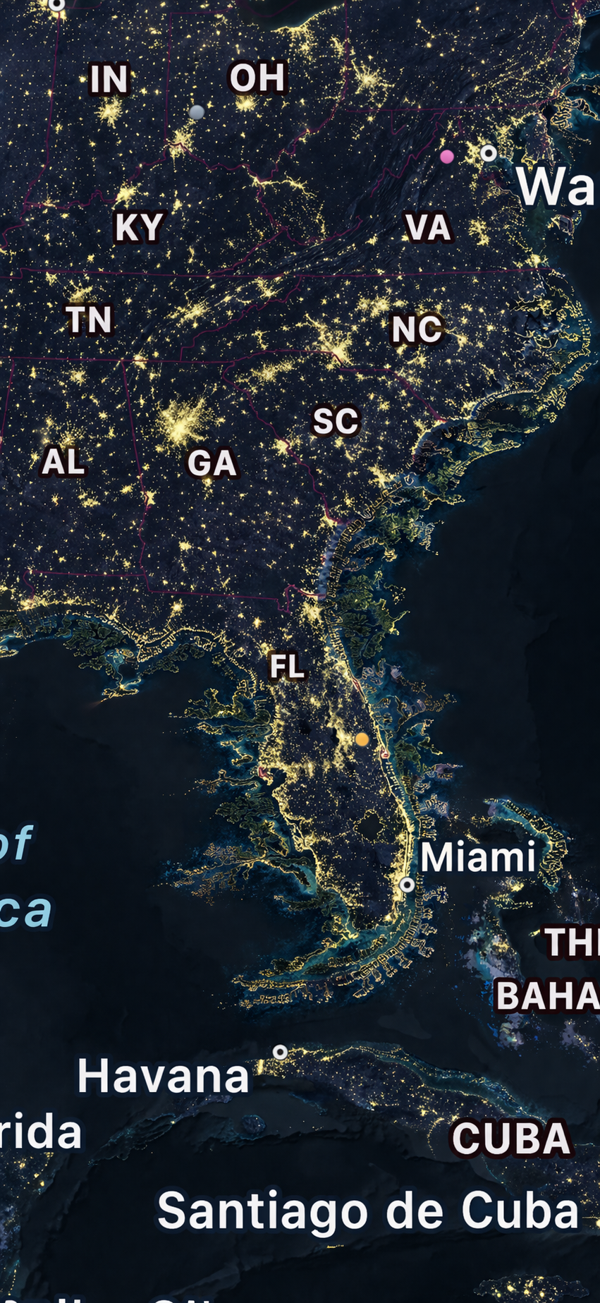
Look at Florida at night.
The peninsula glows unevenly. Light concentrates along the coasts and in a handful of inland patches, with Miami and Tampa defining opposing poles. Most of the interior is dark. Roughly 76% of the state’s population lives in counties that touch the coast, and most of those lights are on a strip roughly ten miles wide.
The coastline itself is the shape that tidal action left when people arrived. A few deliberate cuts for shipping, a few causeways to offshore islands, a few hardened stretches at Miami and Pinellas. Otherwise the outline is an accident of geology and late-Holocene sea level.
The question this corpus starts with is: why is the accident fixed?
The answer is institutional more than physical. The engineering to build new coastline exists, operates at scale, and has been perfected in other parts of the world. What has atrophied in the United States is capacity, permitting throughput, and the conviction that extending territory is a valid exercise of engineering at all.
The map is not sacred
Every square kilometer of the Netherlands below sea level was reclaimed. Singapore has grown its territory by roughly a quarter since independence, from about 580 km² in 1965 to 735 km² today, with 200 km² of the delta explicitly targeted for additional reclamation to 2030. Japan built a functional international airport by terracing 511 ha of Osaka Bay seabed to minus 20 meters and dropping 180 million cubic meters of sand on top, then watching it settle 13.66 m over the next three decades. Denmark is partway through Lynetteholm, a 275 ha island in Copenhagen harbor designed as both a storm-surge defense and a housing supply of 35,000 units. China built 11.6 km² of new reef-supported territory across seven features of the Spratly archipelago in roughly 30 months, from 2013 to 2016.
These are not exotic national efforts. They are ordinary applications of a mature industry. The dredging and ground-improvement toolset that built them is operated globally by four or five large contractors (Boskalis, Van Oord, DEME, Jan De Nul) and dozens of regional specialists. Its methods are catalogued in fifty years of PIANC and IADC proceedings. Its unit costs are reasonably predictable: $3 to $8 per cubic meter for hopper-dredged fill, $5 to $15 for cutter-dredged, $80 to $150 for deep cement mixing.
In the United States this same toolset has built more than most readers would expect. Battery Park City’s 92 acres came from 3 million cubic yards of World Trade Center excavation and harbor dredge. Miami Beach has been continuously renourished since 1976 at a cumulative cost above $200M. Louisiana has rebuilt barrier islands under the Coastal Protection and Restoration Authority since 2009. Galveston raised 500 city blocks by up to 17 feet in the early twentieth century, using 16.3 million cubic yards of hydraulically placed sand. But American reclamation has stayed episodic while the Dutch, the Japanese, the Singaporeans, and more recently the Chinese have built continuously.
Coastline, in other words, is a design variable that most American jurisdictions have stopped touching. The map is treated as though it were sacred. That is a specific civilizational choice, not a physical constraint, and it is worth examining closely.
Florida, as one example
Florida is 58,664 mi² of peninsular land, with approximately 825 miles of sandy open-ocean shoreline and 1,350 miles of total tidal shoreline counting bays and estuaries. Population is 22.6 million, growing at roughly 1% per year. Coastal counties hold 76% of residents and a larger share of property value.
The state was not always this shape. Eight thousand years ago, during the last stages of Holocene transgression, the Florida Platform extended offshore to roughly the modern 20-meter isobath. The Everglades is a late-Holocene feature. The Keys are drowned Pleistocene reef ridges. The barrier islands that define the modern outline are continuously mobile; Key Biscayne, Fire Island, Fort Morgan, and Anastasia Island are all moving measurably within a human lifetime.
The engineering question is not whether Florida’s outline can change. It has changed continuously under natural forcing. The question is whether it can be changed deliberately at useful scale, with appropriate public-safety and environmental design, and whether doing so creates more value than it costs.
A layered extension of the Florida coast configured as parallel barrier belts with protected water between them would roughly double usable frontage per square mile of state area in the counties where it was built. It would absorb storm surge in its outer belt before it reaches the mainland. It would produce protected harbors along currently unusable Gulf and Atlantic deepwater frontages. It would create port sites on both coasts at a time when PortMiami, Port Everglades, and JAXPORT have all reached physical capacity ceilings under existing channel constraints.
Whether Florida should build this is a separate question. This corpus concerns whether it could, what it would take, and what happens if the United States restores the capacity to ask the question seriously.
Frontage compounds
Coastline is the highest-leverage edit to a territory because waterfront and inland land have structurally different economics. Frontage is where trade happens, where people pay to live, and where the military projects force. It is also the substrate on which most human civilization has been built. Forty percent of the global population lives within 100 km of a coast, and virtually every major city predating rail is a port.
Waterfront captures revenue from several independent streams, and the streams are durable.
Battery Park City is the US reference case. The 92 acres were built on harbor dredge and World Trade Center excavation between 1968 and the early 1980s under a public-benefit corporation chartered for the purpose. The Battery Park City Authority holds ground leases to private developers who own their buildings; the Authority collects rent. In 2023 the Authority received approximately $298M in PILOT payments and $57.3M in ground rent, totaling about $382M of annual revenue on 92 reclaimed acres. Since inception the Authority has transferred more than $1.4B net to New York City. Senior bonds carry AAA ratings from Fitch and Moody’s.
Port of Rotterdam’s Havenbedrijf Rotterdam N.V. (HbR), owned 70.83% by the City of Rotterdam and 29.17% by the Dutch State, reported EBITDA of €548.6M in 2023 and €563.5M in 2024 on a port land base where Maasvlakte 2 alone added 1,000 hectares. The European Investment Bank extended €900M at 30-year term to finance the expansion; the loan is serviced from tenant leases on the new land. Net profit has run €247M to €274M annually through the mid-2020s.
Jurong Island in Singapore holds more than S$30B of cumulative tenant investment. The JTC Corporation owns the reclaimed land and grants industrial leases of 20 to 60 years. The consolidated island has recouped the capital cost of reclamation through lease revenue and supports most of Singapore’s downstream petrochemical exports. The Tuas Mega-Port, currently under staged construction through the 2040s, will consolidate all container operations onto reclaimed frontage after its four phases and roughly 1,337 ha of new land complete.
Palm Jumeirah is the cautionary case. $12B capital, off-plan presales for financing, $9.5B Abu Dhabi bailout of Nakheel in 2008 when absorption collapsed. The villas have since recovered: 2024 to 2025 pricing runs AED 15.95M to 200M, up 41% year over year and 63% above the 2014 peak, with Nakheel merged into Dubai Holding in 2024. The lesson is that frontage multipliers do compound, but financing must survive the cycle.
Frontage also captures positive externalities on the land behind it. A port generates logistics clustering. A beach generates tourism and retirement economies. A protected harbor generates marinas, boatyards, fuel sales, and the professional services around them. Producing new coastline creates frontage, and frontage creates all of these downstream industries per unit of state area.
The historical cases cluster where they do for this reason. Reclamation concentrates in city-states and trading nations that understand the multiplier (Singapore, Hong Kong, the Netherlands, Japan, Dubai) and in states extending strategic territory (China in the Spratlys, the US Army in New York harbor through the nineteenth century). It is rarer in large continental economies with abundant interior land, the United States being the prime example.
Layered barrier topology
The geometry of new coastline is not arbitrary. Several decades of coastal engineering practice, combined with a dozen or so actual megaprojects built, have converged on a characteristic topology.
The canonical new-land district has five components.
Outer hard perimeter. Rock armor, caisson, or geotextile-tube core with rock protection. Absorbs the first fraction of wave energy and forms the template for fill placement behind it. Maasvlakte 2 is the reference: 11.3 km of soft beach-and-dune combined with 3.5 km of hard block-armored seawall, 7 million tonnes of rock, 20,000 interlocking concrete armor blocks on the exposed arc.
Fill body. Hydraulically placed sand, typically with internal bunding allowing compartment-by-compartment completion. Maasvlakte 2 used approximately 250 million m³ of sand. Chek Lap Kok used 347 million m³ of combined fill and rock. Haneda D-runway used one-third steel-jacket structure, two-thirds hydraulic fill.
Ground improvement zone. Prefabricated vertical drains, sand compaction piles, deep cement mixing, or combinations. Selected on the consolidation properties of the underlying marine clay and the planned surface loading. HKIA Third Runway used DCM across 650 ha, the world’s largest single application, specifically because the seabed contained legacy contaminated mud pits that could not be dredged without regulatory and environmental escalation.
Surface elevation and freeboard design. Set by design-storm surge plus wave run-up plus subsidence allowance plus sea-level-rise margin over project life. Lynetteholm’s perimeter crests at +2.5 m now, rising to +5.5 m at final build. Maasvlakte 2 standard elevation is +5 m. Kansai Island 1 was built to +4 m and has settled 13.66 m since opening.
Internal protected water. Harbors, lagoons, marinas. Layered barrier extensions produce protected water as a by-product, which is typically more valuable per acre than open sea and sometimes more valuable than the fill itself.
The layered-barrier-belt generalization is multiple parallel belts with protected water between them, spaced to absorb design-storm wave and surge energy in sequence. No single project has built more than two such belts. The principle is established in coastal engineering manuals and has been built at district scale. Extension to state or national scale is the open engineering question.
Precedents exist
Every element of the stack has been built at meaningful scale in the last forty years.
Fill delivery has been demonstrated repeatedly. Maasvlakte 2 placed 250 million m³ between 2008 and 2013 using up to twelve TSHDs simultaneously, with a peak production of 3.8 million m³ per week. Tian Jing Hao placed fill across five Spratly reefs over 193 days in 2013 to 2014, tracked in near real time by commercial AIS. Boskalis and Van Oord operate TSHDs with single-vessel monthly throughput above 10 million m³ and hopper capacities above 40,000 m³.
Deep ground improvement is routine. HKIA 3RS installed over 250,000 DCM clusters from 2016 to 2022, treating a continuous 650 ha footprint. Kansai Phase 1 installed approximately 1 million PVDs. Kobe Port Island and Osaka Bay were built over SCP across their full footprints. The HKIA 3RS approach shows that contaminated marine clay can be treated in situ rather than removed, which is a regulatory as well as a technical advance.
Surge defenses are a mature subfield. Maeslantkering (Rotterdam, 10,000-year return period, 360 m arm span), MOSE (Venice), the Thames Barrier, the Eastern Scheldt Storm Surge Barrier, and the authorized Galveston Ike Dike represent five built or authorized barriers at district-to-bay scale. Design criteria, construction methods, and operational histories are publicly documented.
Institutional templates exist. The Port of Rotterdam Authority is a public N.V. owned 70/30 by the city and the state, issuing investment-grade bonds against long-term tenant leases on reclaimed parcels. Battery Park City Authority, Singapore JTC, PSA International, and Hong Kong Airport Authority are similar structures at varying scales. The Battery Park City model in particular extends cleanly to coastal-extension districts: a public benefit corporation with bonding authority, ground-lease structure, PILOT to the host city, and parks and open space maintained from the revenue.
Economic closure has been demonstrated. Maasvlakte 2 secured the €900M EIB 30-year loan against projected lease revenues. Battery Park City has produced net fiscal transfers above $1.4B since inception while providing 36 acres of public parks without direct taxpayer subsidy.
The engineering stack is catalogued in reclamation-methods. Built-out precedents are in global-precedents and us-precedents. The institutional and economic layers are in economics-and-value-capture and institutions-and-permitting.
What this corpus covers
The corpus sits on a single engineering question: how is new coastline actually produced, and what determines whether it can be done well at scale?
Sixteen documents answer the question across seven sections.
Frame establishes terms. Ontology defines production methods, scale, confidence labels, and anti-patterns used throughout.
The Physical System covers the science every downstream document inherits: sediment budgets and drift cells (coastal-morphodynamics), sediment as the central industrial resource (sediment-as-infrastructure), and engineering for storms and sea-level rise (storm-surge-and-sea-level).
The Engineering covers the production techniques (reclamation-methods), the ecological-integration alternatives (engineering-with-nature), and the industrial base that delivers them (industrial-base).
Precedents catalogues what has been built. Global precedents covers Maasvlakte 2, Jurong Island, Tuas, Spratly, Lynetteholm, Kansai, Kobe, Haneda, Chek Lap Kok, and the Third Runway System. US precedents covers Battery Park City, Back Bay, Treasure Island, Louisiana CPRA, Galveston, Chicago, and Miami Beach nourishment.
Economics, Risk, and Institutions covers value capture (economics-and-value-capture), catastrophe modeling and insurance (risk-and-insurance), and the US permitting stack (institutions-and-permitting).
Application operationalizes all of it for Florida (florida-case-study).
Synthesis and Horizon gives the bootstrapping ladder and venture architecture (roadmap-and-ecosystem) and the extension to other forms of territorial design (beyond-coastline).
Reading paths for different audiences are in the corpus index.
What it does not cover
This is not a book about whether coastal cities should retreat or rebuild. That is a separate conversation about which this corpus takes no position.
It is not a rebuttal to climate-driven retreat arguments. The facts in the corpus inform such arguments but are consistent with several end-state visions, including more defended land, less defended land, or the same land defended differently.
It is not a prospectus. It is reference material. Venture implications are in roadmap-and-ecosystem for readers who want them.
It is not a critique of the US Army Corps of Engineers. USACE has produced extraordinary work on a starved budget and under statutory handcuffs. Where the corpus identifies institutional friction, the friction is described, not moralized.
Florida is one example. The subject is general.