Sand Is the Supply Chain
A land project begins with a governed sediment supply: compatible material, reachable sources, matched equipment, and a schedule that closes before placement starts.
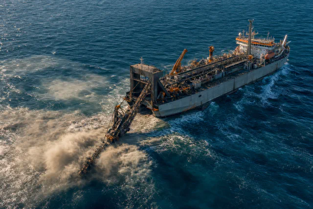
A reclamation plan can reach detailed design before anyone proves that its fill source can actually supply the work.
The borrow area exists on a map. A preliminary volume has been multiplied by a unit rate. The site plan, seawall alignment, and construction schedule all assume that material will arrive. Then the cores come back. The clean sand is thinner than the geophysical model suggested. Fines increase with depth. A cable corridor cuts through the best part of the deposit. The remaining material can still be dredged, but not at the assumed production rate and not for the intended use.
The geometry of the land has not changed. The project has.
The sediment budget explains how material moves after it enters a coastal system. Before that movement begins, sediment has to be found, characterized, authorized, extracted, transported, placed, and accepted. That chain determines whether a fill plan is buildable.
A source is three-dimensional
A borrow area is not a point on a chart. It is a deposit with thickness, internal layers, overburden, variable grading, and boundaries imposed by other uses.
The first useful quantity is not gross volume. It is recoverable compatible volume. That number only appears after the survey has accounted for unsuitable layers, environmental exclusions, infrastructure corridors, side slopes, dredging tolerances, and the material that cannot be removed cleanly without mixing it with what lies above or below.
This is why source investigations combine bathymetry, sub-bottom geophysics, cores, and laboratory testing. Geophysics can trace a reflector between borings, but a reflector does not establish grain-size distribution or contamination. Cores can establish material properties at specific locations, but widely spaced cores can miss channels, lenses, or abrupt changes in a reworked marine deposit. The investigation has to be dense enough for the decision being made. A regional inventory can tolerate uncertainty that a construction tender cannot.
The Bureau of Ocean Energy Management’s Marine Minerals Program treats offshore sand as a managed federal resource. Its work includes resource identification, environmental study, and negotiated access for qualifying public projects. That administrative structure matters because an offshore reserve is not available merely because it is physically present. Federal jurisdiction, lease terms, cultural resources, fisheries, pipelines, cables, habitat, and competing future demand all reduce the volume that can be treated as committed supply.
A useful source model therefore carries ranges. It separates material proved by sampling from material inferred between samples. It reports volumes after exclusions, not before them. It also identifies what additional investigation would retire the uncertainty. Calling a poorly sampled deposit a reserve does not make it one.
Compatibility is a job-specific test
“Sand” is too broad a specification.
Beach nourishment usually requires compatibility with the native beach because grading affects profile response, erosion, public use, and habitat. Florida’s beach-material quality-control rule, for example, requires project-specific sampling and places limits on characteristics such as fines and construction debris. The point is not that one state’s thresholds apply everywhere. The point is that material acceptance follows the receiving environment and intended performance.
Structural fill is judged differently. Its grading, density, drainage behavior, crushability, and contamination affect placement, consolidation, bearing response, and liquefaction potential. Fine dredged sediment may be valuable for raising a subsiding marsh but unsuitable beneath a pavement without containment and ground treatment. Coarser sand may be excellent drainage fill but wasteful where a thin layer of fine sediment is needed to restore wetland elevation.
The same dredged load can also separate during transport and placement. Coarse particles settle near a discharge point. Fines remain suspended longer and move toward decant areas or beyond the containment if water control is poor. A composite sample taken before pumping does not guarantee a uniform deposit after pumping.
The practical sequence is simple:
- Define what the placed material must do.
- Set acceptance criteria tied to that function.
- Characterize the source at the scale of extraction.
- Test whether the dredging and placement method will change the material delivered to each part of the site.
If any of those steps is reversed, the specification becomes an argument after mobilization.
Distance changes the construction system
Transport distance is not a surcharge added to an otherwise fixed method. It can select the method.
A trailing suction hopper dredge can load while moving, sail between source and placement areas, and discharge by bottom doors, pump-out, or other configured means. That mobility is useful when the source is offshore, the haul is significant, or shipping access must remain open. A cutter suction dredge excavates while stationary and pumps through a pipeline. It can maintain a more continuous flow to a nearby site and can cut denser material, but pipeline routing, booster requirements, vessel traffic, and changing fill elevation become part of production.
The USACE dredging and dredged material management manual frames equipment selection around material, site conditions, disposal or placement requirements, environmental constraints, and production. That is the right level of analysis. Vessel labels alone do not decide the job.
Longer transport can mean fewer cycles per day, more exposure to weather, more fuel, and greater dependence on loading and unloading access. Pipeline placement can require rehandling as the shoreline advances. Shallow water may exclude a loaded hopper from the point where its discharge is most useful. A source that is abundant but difficult to reach can be inferior to a smaller source that matches the placement geometry.
These interactions should be tested as a mass-flow schedule, not hidden inside an average unit cost. The schedule should show when each source is available, which equipment can work it, where the material can be discharged, how water leaves the fill, and what happens when weather or maintenance interrupts the chain. If the answer depends on every link operating at nominal production, the source plan is not robust.
Beneficial use is an appointment
Navigation dredging produces material because a channel or harbor has to be maintained. A receiving project needs material because a beach, wetland, levee, island, or fill platform has to be built. The two needs do not automatically meet.
The sediment has to be characterized early enough for both programs. The receiving site has to be permitted, contained where necessary, and ready when the dredge arrives. The dredging contract has to allow the required placement method. Funding and responsibility for any added handling have to be settled. If the material appears six months before the site can accept it, the theoretical resource may still go to its conventional placement area.
This coordination problem is central to the Corps’ current policy. USACE states that the Chief of Engineers has set a goal of beneficially using at least 70 percent of dredged material by 2030. Reaching that goal is not a matter of relabeling all maintenance material as fill. A 2025 USACE stakeholder study identified recurring barriers that include cost allocation, inconsistent policy implementation, limited storage and processing capacity, timing, characterization, and the difficulty of connecting sediment generators with users. The report’s title is accurate: these are hurdles to expanded beneficial use, not evidence of a material shortage alone.
Beneficial use works best as a standing program. Repeated dredging reaches are characterized before an emergency. Candidate receiving sites are permitted in advance. Temporary storage and rehandling locations are identified. Data on grading and contamination are kept in a form that designers can use. The institution that owns the channel knows who can receive the next campaign’s material before the contract is advertised.
Without that structure, each project starts the matchmaking again.
The owner of the source sets the risk
Source governance determines what a project can promise.
Material from a project-owned borrow area can be investigated and sequenced around the construction program, but the owner carries exploration and environmental risk. Material from routine navigation dredging may have low extraction cost already assigned to another purpose, but its timing, grading, and delivery point are controlled by the navigation mission. Offshore federal material requires BOEM coordination. Imported material depends on export policy, port handling, customs treatment, and the willingness of another jurisdiction to continue supplying it.
The correct response is not to assume that every project needs a dedicated offshore mine. It is to build a source portfolio around the uses within the site.
Coarse, clean material may be reserved for drainage layers, exposed beaches, or zones with strict geotechnical requirements. Fine material may be contained in landscape areas or used in wetland cells if chemistry and elevation are suitable. Rock may replace sand in revetments but not in a beach profile. Ground improvement may reduce the need to remove and replace weak foundation soil. A polder or structural deck may reduce fill demand while creating permanent pumping or structural obligations.
Substitution works when it is tied to function. It fails when “alternative material” is treated as a universal category.
The source decision
The project that discovered incompatible material late did not have a sand problem. It had allowed every downstream decision to rest on an unverified supply chain.
That failure can be prevented with a source gate before geometry hardens. At that gate, the team should be able to name the receiving-zone specifications, recoverable volumes by confidence level, extraction constraints, transport and placement system, contingency sources, permits, owners, and schedule interfaces. Any missing item is not paperwork. It is an unresolved design dependency.
Once those dependencies close, the fill plan becomes credible. It still is not a land project. The placed material must occupy an elevation and protection system that works while tides, storms, sea level, and the ground itself move. That is the next decision.