The path from the current state of US coastal engineering to a serious territorial engineering capability runs through three distinct phases. Each phase has prerequisites from the previous one. None of the phases is technically novel. Every element of what needs to be built has been built somewhere before. The constraint, throughout, is institutional and organizational, not physical.
This document maps the sequence, identifies the ventures that could be built at each phase, and explains what determines whether the whole ladder is climbed.
Where the system stands
The current US coastal engineering system has four compounding problems that feed each other.
The fleet is undersized and aging. Three firms hold the majority of domestic dredge capacity. European competitors operate trailing suction hopper dredgers with hoppers above 40,000 cubic meters; the largest US unit under construction carries approximately 15,000 cubic yards, roughly 11,500 cubic meters, one-quarter the European standard. About one-third of US hopper dredges are over 20 years old, and the median age across all vessel classes exceeds 15 years (Florez 2025, p. 7). Annual demand is projected to rise from approximately 175 million cubic yards in 2025 to roughly 400 million cubic yards by 2045 (Florez 2025, p. 5). The fleet that has to absorb that increase is not capable of doing so without structural reform.
Permitting is slow. The average federal project takes 8.2 years from feasibility to groundbreaking (Florez 2025, p. 14). Major coastal or waterway environmental impact statements have historically taken 4.5 years on average, and EIS timelines for projects involving multiple ESA consultations commonly run 5 to 8 years. The full permit stack for a large coastal fill project, spanning pre-application, NEPA EIS, CWA Section 404 individual permit, ESA Section 7 formal consultation, CZMA consistency review, and state 401 water quality certification, runs 5 to 10 years for major projects even in a favorable regulatory environment.
Sediment inventory is incomplete. Southeast Florida’s nearshore beach-quality sand sources are approaching exhaustion. BOEM’s Marine Minerals Program has conveyed approximately 164 million cubic yards of outer continental shelf sand nationally since 1995, but the national offshore sand inventory is not complete. Projects with 10-to-20-year time horizons face sourcing uncertainty that starts before permitting and extends through construction.
Beneficial reuse is below target. The USACE dredges approximately 210 million cubic yards per year from navigation channels. Currently 30 to 40% of that material is reused constructively; the remainder goes to offshore or upland disposal. The USACE target is 70% beneficial reuse by 2030 (Florez 2025, pp. 3, 8). Reaching that target would redirect roughly 73 million additional cubic yards per year from disposal into beach nourishment, marsh restoration, and land reclamation, effectively increasing productive output without increasing extraction.
These four problems are related. Slow permitting extends project timelines and raises unit costs. An undersized fleet cannot clear backlogs even when permits do arrive. An incomplete sediment inventory forces project-by-project sand searches that could be handled through strategic pre-positioning. Low beneficial reuse rates waste material that could reduce demand on new extraction. Fixing any one of the four in isolation helps at the margin. Fixing all four in sequence produces a different industrial system.
Phase 0 to 2 years: enabling
The first phase does not require new fleet or new demonstration projects. It requires institutional and contractual changes that remove the uncertainty suppressing private capital formation.
Contracting reform is the highest-leverage action in this window. USACE procurement currently relies on fixed-price, single-year contracting structures that make sustained capital investment in fleet capacity unprofitable. A dredge costs $50 million to $200 million and has a 30-to-40-year useful life. No contractor builds a vessel on speculation that USACE projects will materialize in the right sequence to service the debt. The Florez (2025, pp. 13, 17) proposal for multi-year outcome-based contracts and availability payments is the minimum reform. A multi-year contract with demand certainty changes the business case for fleet investment fundamentally. Statutory authority for these structures does not currently exist at the scale required. New Congressional authorization, most naturally through a Water Resources Development Act reauthorization cycle, would need to permit multi-year contract terms and performance-based payment structures for navigation and coastal work.
The allied surge agreement supplement addresses the emergency gap during the contracting reform transition. MOUs with the Netherlands, Belgium, Japan, and South Korea allowing foreign-flagged dredges to operate in US waters under emergency conditions, subject to CFIUS review, provide a backstop that purely domestic procurement reform cannot. Florez (2025, p. 17) proposes this as an immediate action; it acknowledges that the US cannot build its way out of a post-storm emergency with domestic capacity alone. The regulatory path for emergency activation needs to be defined in peacetime, not improvised after a Category 4 landfall.
A national sediment inventory is the second enabling action. BOEM’s Atlantic Sand Assessment Project has collected cores offshore 11 Atlantic states, but reserve characterization is incomplete. Completing the national offshore sand inventory, at reserve classification standards comparable to BOEM’s oil and gas methodology, is the precondition for project financing. A lender offering 30-year infrastructure finance against a coastal reclamation district needs to know where the sand comes from for project years 8 through 20. That information does not exist in complete form for most US coastal segments. BOEM Marine Minerals Program expansion, with accelerated survey and leasing authority, is the mechanism. The Florez (2025, p. 17) mid-term category puts “complete national offshore sand inventory” in the three-to-five-year window; given the 5-to-8-year permitting timelines for the projects that will use it, this is actually a zero-to-two-year priority if it is to be ready when needed.
Sediment management districts reorganize the administrative geography around sediment as a strategic resource rather than a navigational byproduct. A district approach creates a defined geographic unit within which USACE, BOEM, state agencies, and local governments coordinate sediment budgeting, beneficial reuse placement, and offshore inventory management. The closest existing analog is the regional coordination structures under the CWPPRA in Louisiana, which have operated for over three decades and placed 193 million cubic yards cumulatively through 2023. Scaling that model nationally, with formal statutory structure and dedicated funding, is achievable without new engineering.
Programmatic EIS expansion uses the 2020 South Atlantic Regional Biological Opinion as the template. The SARBO is a single multiyear consultation covering USACE and BOEM dredging and nourishment activities from the NC/VA border through Key West, allowing individual projects to proceed under a pre-cleared framework rather than initiating new ESA Section 7 consultation from scratch. Extending this model to cover additional geographic regions, additional species (the 2020 SARBO covers a specific list of listed species in the Southeast Atlantic; analogous programmatic instruments covering the Gulf of Mexico and the Pacific coast do not exist in equivalent form), and additional project types would compress the per-project permitting timeline from 5 to 10 years toward 1 to 3 years for qualifying projects. The FRA of 2023 codified a 2-year EIS statutory target; programmatic coverage is what makes that target achievable in practice for coastal and dredging work.
Beneficial reuse target adoption translates the USACE 70% target into contractual and funding structures that actually change disposal behavior. The barrier is not the goal; it is the matching mechanism. Beneficial reuse requires coordinating dredge operating schedules with placement windows, maintaining permits that allow placement without triggering full individual project review for each event, and funding the incremental cost of beneficial placement over disposal. SARBO-style programmatic coverage is part of the solution. Dedicated beneficial reuse line items in USACE O&M appropriations are the other part.
The two-year phase does not produce new coastline. It produces the institutional substrate that makes new coastline economically viable in the phases that follow. The analogy is permitting a new road: the road does not exist until someone builds it, but no one builds it until the permit exists.
Phase 3 to 5 years: capability
The second phase is where capital goes to work on physical systems. The enabling work of Phase 0 to 2 creates demand certainty; Phase 3 to 5 deploys capital against that certainty.
Fleet recapitalization at $3 billion is already underway in partial form. Private dredging companies have invested more than $3 billion in new US-built dredges since 2018 (Florez 2025, p. 7). What that investment produces, under current parameters, tops out at approximately 15,000 cubic yards of hopper capacity per vessel, versus 46,000 cubic meters for European equivalents. The gap remains roughly four to one even after the current investment cycle. Closing the gap requires either modifying the Foreign Dredge Act of 1906 to allow foreign-built vessels under US flag in specific operational categories, or creating accelerated depreciation schedules and Title XI shipbuilding loan guarantees that change the economics of building larger vessels domestically. The Florez (2025, p. 17) proposal for tax credits and accelerated depreciation for US-built dredges is in the three-to-five-year policy tier, which is where the capital formation would need to produce vessels by the end of the window.
Fleet recapitalization is not only about large trailing suction hopper dredgers. Cutter suction dredger capacity matters for inlet work, confined channel deepening, and CSD-appropriate applications. The DEME Spartacus, the world’s largest CSD, operates at 6,000 cubic meters per hour rated output. The US CSD fleet has no equivalent. A comprehensive fleet strategy covers vessel classes, not just TSHD hopper capacity.
Autonomous dredging pilots move from European R&D programs to US demonstration projects. Boskalis and Van Oord have both announced R&D investment in autonomous vessel operation. The engineering path for autonomous TSHD production dredging, where a vessel selects its own borrow area, manages draghead contact, transits without crew, and positions for discharge, is technically clear. The regulatory path is not. USCG certification and USACE quality-assurance requirements for dredged material placement have not been adapted for autonomous operation. A US demonstration project, structured as a research partnership with USACE, USCG, and a domestic dredging contractor, would produce the regulatory precedent that a commercial deployment requires. The Florez (2025, p. 17) roadmap places autonomous dredging in the long-term tier; the demonstration infrastructure needs to start in the three-to-five-year window to produce commercially actionable regulatory precedent by year 6 to 10.
AI-driven fill placement and design is a closely related capability that does not require autonomous vessels. Current practice uses pre-shift survey and post-shift survey with manual QC between them. Closed-loop real-time control, where placement quality is assessed from multibeam sensor feeds during production and discharge targeting is adjusted to optimize against design specification, reduces over-placement and under-placement deficiencies that together add cost to every project. This is Plausible by the ontology classifications: the sensor fusion and machine-learning tools exist; they have not been integrated into production dredge operations at commercial scale.
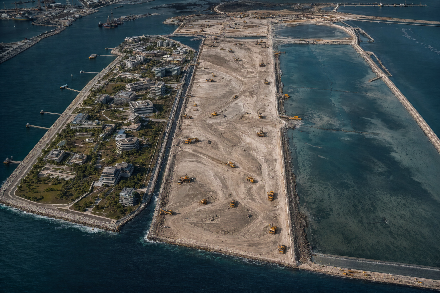
The first demonstration district is the central milestone of Phase 3 to 5. A sub-100 hectare pilot on the lower end of the district scale, structured as a public-benefit corporation with bonding authority on the Battery Park City Authority model, demonstrates the economic closure of coastal reclamation under US conditions. The site selection matters. The pilot should be in a location where the following conditions hold: existing political support for coastal infrastructure investment, access to sediment sources that can be sourced without multi-year supply risk, a permitting environment where the Phase 0 to 2 programmatic instruments have taken effect, and an economic model where ground-lease revenue at built-out density covers debt service.
Battery Park City is the reference. The 92-acre BPCA-developed district now generates approximately $382 million per year in PILOT payments and ground rent, carries AAA-rated senior bonds, and has transferred more than $1.4 billion net to New York City since inception. The BPCA was created by the New York State Legislature in 1968, received its first fill from World Trade Center excavation and harbor dredge spoil between 1968 and the early 1980s, and reached current revenue levels over a 40-year build-out. The demonstration district in Phase 3 to 5 would be smaller in scale and much faster in permitting, because the institutional infrastructure built in Phase 0 to 2 compresses the timeline. Whether a demonstration at 50 to 100 hectares in a Gulf or Atlantic coastal location can reach BPCA-scale revenue ratios depends on density assumptions and ground-lease pricing that vary by market. The principle is demonstrated; the local parameters require site-specific feasibility work.
A BPCA-structure special district works for urban or port-adjacent sites where the political authority to create a state-chartered public benefit corporation exists. A Florida community development district (Ch. 190) or stewardship district (Ch. 189) structure works for development-focused applications where the landowner-vote-at-inception mechanism is feasible. The 2008 Florida CDD default wave, in which 168 CDDs defaulted on approximately $5.1 billion face value of bonds, is the cautionary case: speculative absorption projections collapsed when the residential market turned. Coastal reclamation districts with diversified revenue streams (port, industrial, mixed-use, and park) are structurally more resilient than single-product residential CDDs, but the financing structure and absorption timing still require conservative underwriting.
Parallel placement systems address the rate constraint on fill delivery to defined locations. A TSHD delivering fill by rainbowing can discharge up to 80 meters from the vessel at a 30-degree nozzle angle, which limits positional precision. Pipeline-fed hydraulic fill, where the dredge pumps to a floating pipeline that terminates at a fixed discharge point, gives tighter placement control but limits vessel mobility. Running multiple discharge paths simultaneously, from multiple vessels, with real-time coordination of fill elevation against a digital model, is the direction AI-driven placement takes. This is not a single-vendor technology; it is an integration of positioning systems, survey technology, and process control that the major European contractors have been developing for fifteen years. The Phase 3 to 5 window is when US operators should be acquiring the capability, not inventing it.
Phase 6 to 10 years: scale
The third phase operates the system built in the first two phases at multi-project scale.
Multi-district programs apply the demonstration district model across multiple geographic regions. The value of the demonstration is not the single project’s revenue; it is the regulatory, financial, and operational template that allows the second and third projects to start from an established baseline. Lynetteholm in Copenhagen took a Folketing vote of 85 to 12, a construction start in January 2022, and an injunction denial from Ostre Landsret in March 2024, then proceeded to a DKK 2.15 billion Phase 2 contract. The institutional momentum of a demonstrated project is difficult to recreate from scratch for each new site. The Florida case study that this corpus develops in florida-case-study illustrates where multiple districts might be sequenced, given the regional variation in shelf geometry, sediment access, storm exposure, and existing port constraints.
Continuous hopper replacement cadence means that by year 6 to 10, the contracting reform and financing structures from Phase 0 to 2 have produced a sustained vessel-building cycle, not a one-time recapitalization event. European operators refresh their fleets continuously because continuous project demand justifies it. The goal of the US policy sequence is the same self-sustaining dynamic. Florez (2025, p. 5) projects demand at approximately 400 million cubic yards per year by 2045, roughly double current levels. A fleet that meets that demand requires roughly double the current throughput capacity, which at US productivity rates requires more than double the vessel count compared to European productivity levels. Getting to European productivity rates is the work of Phase 3 to 5; sustaining the fleet required to run at that rate continuously is the work of Phase 6 to 10.
Integrated design-simulate-place-monitor loops represent the mature form of AI-enabled coastal engineering. In the mature system, a coastal extension project is designed using cat-model-integrated topology optimization, where the design software simultaneously optimizes site geometry for storm-surge attenuation, fill volume efficiency, and economic density; simulated against validated hydrodynamic models (Delft3D, MIKE21, XBeach class) to confirm performance against design-storm conditions; executed with AI-driven placement control that compares real-time fill elevation to the design specification on a continuous basis; and monitored post-completion by satellite and in-situ sensor networks that feed back into the next design cycle. No single project has operated this full loop as an integrated system. The components are Demonstrated or Engineered individually. Integration at project scale is Plausible, using the ontology confidence labels.
The value of the integrated loop is reduction of the principal risks that have defined the worst outcomes in coastal reclamation history. Kansai International Airport Island 1 settled 13.66 meters, against an original prediction of 5.7 to 5.8 meters, a factor of 2.4 underestimation. The Pleistocene clay anomaly that drove this, continued compression below pre-consolidation pressure, was not predicted by classical consolidation theory. A real-time settlement monitoring network feeding back into operational decisions, combined with a Bayesian model updating framework that revises geotechnical predictions as observed settlement data accumulate, would not have prevented the settlement but would have allowed earlier intervention in the adaptive pile-jacking system that NKIA eventually installed. Kansai Terminal 1 runs on 900 adjustable jack columns that are incrementally re-leveled as the foundation sinks. The system works; it was installed after the settlement was already dramatic rather than designed in from the start.
Platform companies
The industrial system described in the three phases above produces commercial opportunities for companies that build enabling infrastructure. These are platform plays, not application-specific vertical plays. They derive value from the system running at scale regardless of which specific projects execute.
Sediment marketplace. The fundamental supply-demand clearing problem in coastal engineering is that dredged material, maintenance spoil, and beneficial reuse demand are not matched by any market mechanism. USACE districts manage maintenance contracts through procurement channels that do not see regional beneficial reuse demand. A coastal county that needs 3 million cubic yards of beach-compatible sand for a 15-year nourishment program does not have visibility into which USACE projects will produce compatible material in their region over that period. A marketplace that aggregates supply from maintenance dredging programs, BOEM-leased OCS sources, and private excavation, and matches it against demand from nourishment programs, reclamation projects, and wetland restoration, captures the coordination cost that currently sits as friction in every project. Revenue model: transaction fee on matched volume, data subscriptions to project sponsors, and fee-for-service sediment characterization. The USACE beneficial reuse target of 70% by 2030 is the upstream policy driver; if it succeeds, it creates a volume of actively managed beneficial reuse material that needs a clearing mechanism.
Autonomous dredge operator. Fleet leasing combined with AI placement software is a distinct business from building dredges. An autonomous dredge operator owns or leases vessels, installs its own sensor and software stack for positioning and placement control, and sells throughput capacity by the cubic meter to project sponsors. The revenue model is analogous to Rolls-Royce Power By The Hour, where the operator sells output rather than equipment. The autonomous placement premium over conventional dredging comes from reduced over-placement and deficiency costs, reduced vessel idle time from better scheduling, and the ability to run projects continuously rather than in mobilize-operate-demobilize cycles that add cost. This company is the commercial consolidation of the autonomous dredging pilot work from Phase 3 to 5. It exists only if the regulatory precedent from the demonstration pilot is in place.
Permitting SaaS. The 5-to-10-year permitting timeline for major coastal projects is partially a workflow problem. Each application requires assembling the same categories of supporting documentation, the same biological assessments, the same hydrodynamic models, the same alternatives analysis, across slightly different regulatory formats for each agency and jurisdiction. A software platform that maintains a structured data model for a project from pre-application through construction, integrates with USACE permitting portals, BOEM leasing databases, and state CZM systems, and tracks ESA consultation status, SARBO coverage eligibility, and Section 404/401 milestones, reduces project coordination cost and compression misses. Revenue model: SaaS subscription by project, with per-agency module pricing. Market size: every federally permitted coastal project in the US. Comparable: Verint or similar regulatory workflow software applied to environmental permitting. The competitive position comes from domain-specific data models for CWA/ESA/CZMA intersection, not from generic workflow tooling.
Coastal-AI design firm. The integrated design loop from Phase 6 to 10 requires a firm that can run the full stack: topology design, catastrophe model integration, hydrodynamic simulation, and fill optimization. This is a consulting and software business combined. The consulting revenue comes from design contracts on specific projects; the software revenue comes from licensing the simulation and optimization toolchain to other engineering firms. The catastrophe-model integration is the differentiating capability. Insurance underwriters for coastal reclamation projects need peril-by-peril loss estimates that treat the engineered land as a distinct risk category from legacy coastline. No general-purpose cat model (Verisk/AIR, Moody’s RMS) has an engineered-reclamation land type. The design firm that builds the toolchain to generate defensible loss curves for engineered coastal land is the same firm that can sell it to the insurance market.
Insurance-structuring vehicle. Engineered coastal land is a new asset class that does not fit cleanly into existing insurance product structures. Legacy cat models calibrated to natural coastline underestimate the protective value of designed berms, outer belts, and flood barrier systems. Risk Rating 2.0 at NFIP looks at structure-by-structure elevation; it does not credit a multi-layer designed landform. A vehicle that structures parametric and indemnity coverage for engineered-land districts, using the coastal-AI design firm’s loss curves, fills a market gap. Revenue model: program manager fees, fronting carrier relationship, and captive reinsurance structure. The analogy is specialty insurance programs for natural catastrophe, structured with capital market access through ILS tranches. Cat bond outstanding at end-2024 reached $49.5 billion globally, with $17.7 billion issued in 2024 alone. Engineered coastal land, if it can be risk-rated defensibly, is a credit-positive asset relative to legacy coastal land.
Vertical plays
Platform companies generate value from the system operating at scale. Vertical plays capture the application-specific value created at specific sites.
Florida district developer. Florida has approximately 1,088 community development districts and stewardship districts active as of August 2025. None of them is structured as a coastal reclamation district on the BPCA model. The Florida legislature has shown willingness to create purpose-specific district structures when the economic and political case is made: Reedy Creek (now CFTOD) for Disney World, and twenty-one stewardship districts with expanded governance powers, are precedents for special-purpose territorial authority. A company that specializes in creating Florida coastal extension districts, structuring the financing, managing the permitting stack, and executing the fill placement has a defined target market. Florida accounts for 22 of the 58 national BOEM marine mineral leases issued since 1995, which reflects both the demand and the offshore sand resource base. The state has 409.9 critically eroded miles of coastline; its beach nourishment program has spent more than $1.9 billion over 87 years; and a $44 million state investment generates a $2.4 billion GDP increase from beach economics. The political and economic case for coastal investment is established. The institutional architecture for persistent capital structures is not.
Port extension operator. PortMiami deepened from 42 feet to 50 feet at approximately $205 million and 5 million cubic yards of dredging, completed in 2015. JAXPORT deepened from 40 feet to 47 feet at $420 million, completed May 2022, seven months ahead of schedule. Both projects were channel-deepening operations that extended existing port capacity within existing footprints. The next set of port capacity constraints in Florida and the Gulf Coast will not be solvable by channel deepening alone; the physical constraints at PortMiami, Port Everglades, and JAXPORT include channel width limits and terminal area limits that require new land, not just deeper water. A port extension operator that partners with US port authorities to plan, permit, and execute reclamation-based terminal expansions captures the port capital expenditure market that has historically been spent on deepening rather than expansion. Georgia Ports Authority’s 10-year capital plan runs $4.5 billion for 5 new big-ship berths at Savannah and 4 at Brunswick. The operator that can convert part of that into reclaimed land-based terminal area has a large, creditworthy customer base.
Resort-coastal developer. Palm Jumeirah cost approximately $12 billion, financed through off-plan presales at 30 to 50% deposits, required a $9.5 billion Abu Dhabi bailout in 2008 when absorption collapsed, and has since recovered to 2024-to-2025 villa pricing of AED 15.95 million to 200 million, up 41% year-over-year and 63% above the 2014 peak. The lesson from Palm Jumeirah is not that resort coastal development on reclaimed land is unviable; it is that absorption timing matters and that financing must survive the construction-to-absorption cycle without relying on continued off-plan presales to fund construction. A US resort-coastal developer applying the engineered-land model to coastal Florida, the Gulf, or the mid-Atlantic, with conservative absorption projections, conventional construction financing rather than presale-dependent structures, and diversified amenity programming that supports hotel and marina revenue during the residential absorption period, is Plausible. The precedent is Battery Park City: 40 years of absorption, at conservative pace, producing AAA-rated bonds throughout. Palm Jumeirah is the cautionary bound on what presale-dependent financing structures do when absorption stalls.
The research foundation
Some of what the ecosystem needs does not belong in a for-profit structure.
An open-source national sediment inventory, contributed to and maintained by a public or public-benefit institution rather than monetized as proprietary data, serves all market participants including competitors of any company built on this roadmap. BOEM data is technically public; the Atlantic Sand Assessment Project cores and characterization data are public record. The gap is structured compilation, standardized classification, and accessible tooling for project planners to query the inventory against project-specific specifications. A research foundation that maintains this resource, funded by a mix of federal cooperative agreement and industry subscription, is the appropriate structure because the marginal value of the data is highest when it is shared, not withheld.
Public-benefit R&D on ecological performance of reclaimed land is a second category. How does engineered coastal substrate compare to natural coastal habitat for listed species over 10 and 20 year time horizons? The question matters for every ESA Section 7 consultation on every future project, but no single company benefits from having the answer more than its competitors. Neutral institution research, published and peer-reviewed, produces usable regulatory credit for the whole industry. The USACE Engineering With Nature program and the CWPPRA monitoring database are the existing frameworks; a research foundation that expands their scope to engineered reclamation habitat specifically, and builds the dataset that would support programmatic biological opinion coverage for new project types, produces public value that compounds.
Policy work belongs in the foundation because the policy reforms in Phase 0 to 2 require sustained advocacy over time horizons that exceed typical venture investment cycles. A company that successfully permitted the first demonstration district has an obvious commercial interest in the regulatory framework that enabled it; but sustaining the advocacy for the second and third reform cycle, with arguments grounded in performance data from the first projects, is better done by an institution whose credibility does not depend on a financial stake in specific projects.
The research foundation does not generate a financial return to equity holders. It generates the regulatory and epistemic environment in which equity returns become possible for the commercial ventures.
Decision filters
The roadmap above is not the only possible structure for building coastal reclamation capability in the United States. Two filters determine which ventures to pursue and in which sequence.
Why these ventures and not others. The platform companies listed above are selected because they address frictions that affect the whole system rather than optimizing within a fixed friction level. Permitting SaaS does not change the legal requirements; it reduces the coordination and documentation cost of meeting them. An autonomous dredge operator does not build a faster-permitting environment; it reduces the cost per cubic meter within whatever permitting environment exists. These companies are valuable regardless of which specific districts get built, which specific ports expand, and which insurance structures succeed. The vertical plays are more exposure-specific; they capture value at particular sites and market segments where the platform companies have reduced friction enough that the economics close. The research foundation addresses what cannot be captured by any single commercial entity. Together these three layers cover the full range of value creation that a functional territorial engineering ecosystem requires.
What breaks the Phase 0 to 2 plan. Two scenarios could disrupt the enabling phase before it produces the Phase 3 to 5 investments.
Political timing risk is the first. The Florez (2025) policy sequence requires sustained administrative attention across a period likely spanning multiple administrations. The 2020 SARBO took years of multi-agency coordination to produce; a successor administration could restrict its application or decline to extend it. The Foreign Dredge Act waivers needed for allied surge agreements require State Department engagement and CFIUS review structures that can be reversed. Multi-year contracting reform legislation for USACE dredging requires Congressional action. Any of these could stall or reverse during the enabling phase, extending timelines for the capability phase.
The Florida insurance insolvency wave creates a counter-scenario that could accelerate rather than slow the ecosystem. Citizens Property Insurance Corporation peaked at approximately 1.42 million policies in October 2023, representing roughly 19% of Florida homeowners policies statewide. Seven carriers were declared insolvent between 2022 and early 2023, with the Florida Insurance Guaranty Association covering claims from 10 total insolvencies involving 440,000-plus policies at approximately $1.6 billion cost. SB 2-A in December 2022 reduced litigation exposure and began stabilizing the market, and Citizens fell to approximately 336,000 policies by early 2026. But the underlying exposure concentration in coastal counties has not changed. If a major storm, Hurricane Ian-level or above, strikes before market stabilization is complete, the insolvency wave could accelerate toward a situation where private insurance becomes unavailable for conventional coastal land over large portions of the Florida coast. That outcome would accelerate demand for engineered coastal land rated differently by insurers, which is exactly the product the insurance-structuring vehicle is designed to deliver. Forcing functions change the political calculus for the enabling reforms faster than gradual pressure can.
The forcing-function scenario should not be counted on and should not be planned for. It should be understood as the condition under which the timeline to build operational capacity compresses from 6 to 10 years to 2 to 4.
The venture table
| Company | Layer | Role | Revenue model | Phase |
|---|---|---|---|---|
| Sediment marketplace | Platform | Supply-demand clearing for dredged material | Transaction fee, data subscription | 3-5 yr |
| Autonomous dredge operator | Platform | Fleet leasing + AI placement software | Per-cubic-meter throughput fee | 3-5 yr |
| Permitting SaaS | Platform | NEPA/404/401/ESA workflow tooling | SaaS subscription by project | 0-2 yr |
| Coastal-AI design firm | Platform | Cat-model-integrated reclamation design | Design contracts + software license | 3-5 yr |
| Insurance-structuring vehicle | Platform | Engineered-land insurance products | Program manager fee, ILS tranches | 6-10 yr |
| Florida district developer | Vertical | BPCA-structure districts for FL coastal extension | Ground lease revenue, development fee | 3-5 yr |
| Port extension operator | Vertical | Partners with US port authorities on reclamation terminals | Development fee, long-term operating stake | 3-5 yr |
| Resort-coastal developer | Vertical | Palm Jumeirah lessons in US coastal markets | Sales, ground rent, hotel operating | 6-10 yr |
| Research foundation | Public benefit | Open sediment inventory, ecological R&D, policy work | Federal grants, industry subscription | 0-2 yr |
The roadmap has a logic that runs through every layer. Institutional reform in the first phase creates demand certainty. Demand certainty attracts capital into fleet and demonstration projects in the second phase. Demonstrated projects in the second phase produce the regulatory templates, financial precedents, and operational experience that scale programs in the third phase require. Platform companies built on each phase’s output generate returns that are not tied to any single project outcome. Vertical plays capture site-specific value where the platform infrastructure has made the economics work.
None of this requires a technological breakthrough. The engineering is documented in fifty years of PIANC and IADC proceedings. The financing structures are demonstrated at Maasvlakte 2 and Battery Park City. The permitting framework exists in the 2020 SARBO. The fleet investment is already underway. What requires work is the sequence, the patience to build enabling infrastructure before capitalizing on it, and the analytical rigor to distinguish which ventures create value at which phase rather than trying to build everything simultaneously.
The political timing risk is real. The forcing-function scenario is plausible. The companies in this table are worth building regardless of which one of those paths materializes, because the demand for coastal sediment management is growing at roughly 50% over twenty years (Florez 2025, p. 2) in an environment where the industrial base cannot currently meet demand that already exists.
That is a durable structural opportunity. The question is sequence, not viability.
The industrial base constraints are quantified in industrial-base. The permitting stack is detailed in institutions-and-permitting. Florida-specific phasing, site selection, and regional sourcing are in florida-case-study. Economic closure models for the demonstration district are in economics-and-value-capture.