How New Land Is Built
Reclamation as a controlled sequence of investigation, containment, placement, ground treatment, drainage, monitoring, and use-specific acceptance.
The new platform is dry enough to drive across. Survey stakes stand above a broad, level surface. From the perimeter road, the land appears finished.
The instruments disagree. Settlement plates are still moving. Piezometers show excess pore pressure trapped in the foundation clay. A permanent building would add load before the ground has finished responding to the fill already placed.
Construction can begin safely only when the remaining geotechnical response fits the buildings, utilities, and schedule that will follow. Starting sooner transfers an understood soil process into an uncontrolled structural problem.
Reclamation is often described by its visible equipment: dredgers, pipelines, seawalls, cranes. The actual method is the sequence that connects a future use to the soil and water beneath it. Investigation defines the site. Containment makes placement possible. Fill adds load. Drainage and treatment govern the ground response. Monitoring decides when the platform is ready. If any link is treated as a separate contract package, the finished surface can conceal an unfinished system.
Start with the use
There is no general acceptance standard for new land.
A landscaped berm can tolerate deformation that would disable a container crane rail. A road embankment can be resurfaced. A gravity sewer cannot easily recover from a reversed slope. Runways, buried utilities, tanks, quay walls, and occupied buildings each impose different limits on total settlement, differential settlement, bearing capacity, lateral movement, vibration, and construction time.
Those limits belong at the beginning of the work. They determine how deeply the site must be investigated, whether weak layers can remain, how quickly fill may be placed, what ground improvement is justified, and how long the owner must wait before handoff.
The intended use also sets the geometry. A port needs a load-bearing edge and controlled water depth. A polder needs a closed perimeter, internal drainage, and dependable pumping. A coastal district needs routes, utility corridors, and flood-storage areas that remain functional while the platform settles. A nature reserve may need low-strength fine sediment placed at an elevation that supports vegetation rather than structures.
Method selection starts with two questions: What must this piece of ground do? Which failure modes would prevent it?
Investigation can move the project
Bathymetry defines water depth, slopes, channels, and the volume needed to reach grade. Borings and geophysics define the foundation beneath that volume. Sampling identifies compressible clay, loose sand, organic deposits, buried channels, rock, debris, and contaminated sediment. Groundwater and tidal measurements show how pressure will move through the site. Seismic assessment determines whether loose saturated layers can liquefy or whether an embankment can remain stable under cyclic loading.
These findings can move the location itself.
A deep pocket of soft clay may make one quay alignment slower and more expensive than another. Contamination may favor in-place treatment over excavation, or may make a proposed drainage route unacceptable. A buried channel can become a settlement trough beneath a road or utility corridor. An erodible seabed can turn an otherwise adequate caisson foundation into a scour problem.
Investigation should support three outcomes: keep the site, shift the demanding uses within it, or reject the site. A process constrained to the first outcome merely documents a prior commitment.
The USACE dredging and dredged material management manual treats sediment properties, equipment, transport, placement, and environmental constraints as connected decisions. The same connection has to extend below the seabed. Fill behavior cannot be separated from foundation behavior.
The edge is part of the foundation
Containment establishes where fill can be placed, how water can leave, and what loads reach the existing ground.
An armored embankment spreads its weight across a broad footprint. It can be built in stages so a weak foundation gains strength as pore pressure dissipates. That broad section also consumes space and material, and its toe remains vulnerable to scour if the hydraulic design and foundation protection are incomplete.
Sheet piles create a much narrower edge. That is useful beside navigation channels or existing development, but the apparent economy in footprint moves the design burden into penetration, tiebacks, corrosion allowance, interlock behavior, and compatibility with settling fill. A wall that remains vertical while the platform behind it moves can impose severe loads on utilities and pavement at the connection.
Caissons can form quay faces or deep marine boundaries where a prepared bearing bed can be built. Their performance depends on foundation preparation, leveling, sliding and overturning resistance, backfill response, joint behavior, and scour protection. Weak-ground analysis remains necessary regardless of their mass.
A polder avoids raising the entire enclosed seabed with imported fill. On a suitable shallow and containable site, that can reduce material demand. It also converts construction infrastructure into permanent infrastructure. Pumps, gates, seepage control, drainage channels, backup power, inspection, and emergency operation remain necessary for as long as the enclosed land stays below outside water levels.
The USACE levee design manual makes the underlying point clear: seepage, slope stability, settlement, foundations, drainage, and construction sequence have to be evaluated together. Perimeter design controls both fill retention and the hydraulic and geotechnical behavior of the site.
Temporary works belong in the same design. Starter dikes, access trestles, pipeline crossings, decant structures, silt controls, and storm closures carry risk before the permanent section exists. The project is often most exposed while the perimeter is incomplete and the fill is low.
Placement is controlled loading
The dredger is selected after the source, route, receiving geometry, and ground response are understood.
A trailing suction hopper dredge loads while moving, carries material in its own hopper, and sails between source and site. It suits work where the vessel can reach the deposit, load compatible material, transit the haul, and discharge at a useful point. Its operation is cyclic. Weather, sailing distance, draft, traffic, and access to the placement area control the cycle.
A cutter suction dredge excavates while held on spuds or advanced across the cut and sends material through a pipeline. Its continuous hydraulic transport can suit harder material and shorter, protected routes. Pipeline alignment, booster stations, pumping head, navigation crossings, wear, and the rising elevation of the fill then control the operation.
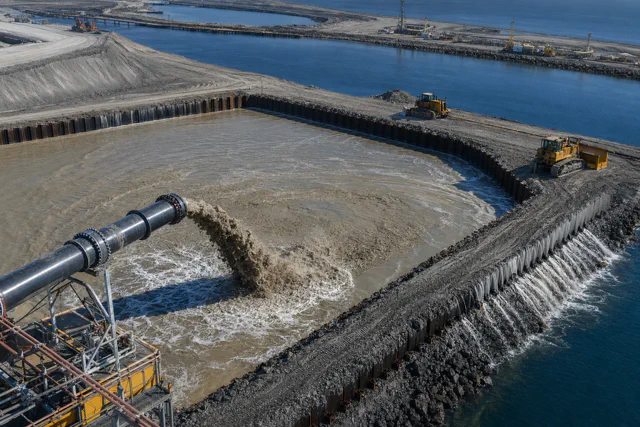
Neither vessel creates uniform land by itself. Hydraulic placement sorts material. Coarser grains settle near the discharge. Fines travel farther with the return water. Moving the discharge, controlling lift thickness, managing decant points, and surveying the deposit are part of the method.
Each lift also loads the foundation. If fill is placed faster than a low-permeability soil can drain, excess pore pressure rises and effective stress falls. Stability can govern long before the target elevation is reached. Staged construction allows observation between lifts. The next stage proceeds because measured pore pressure, settlement, and lateral movement remain within the design path, not because the previous stage is visible above water.
Improvement follows the failure mode
Ground improvement should be zoned by failure mode rather than applied uniformly across the platform.
Prefabricated vertical drains shorten the distance that water must travel out of compressible fine-grained soil. Preload or surcharge supplies the stress that drives consolidation before permanent construction. The combination can bring much of the expected settlement forward in time. It does not eliminate settlement, correct every weak layer, or guarantee uniform response. Drain spacing, smear during installation, drainage at the surface, staged loading, and the actual consolidation curve control performance.
Densification addresses a different problem. Vibration, compaction, or related methods rearrange loose granular fill into a denser state, improving stiffness and reducing liquefaction susceptibility. Their effectiveness declines as fines interfere with drainage and grain rearrangement. A method selected for clean sand cannot be assumed to work after the source grading changes.
Deep mixing treats weak soil in place with a binder to create stronger, stiffer, and often less permeable material. It is useful where the foundation needs added strength, lower compressibility, or seepage control, and where excavation or years of waiting are impractical. The actual soil-binder response sets the design strength. The FHWA deep mixing design manual emphasizes laboratory studies, field trials, installation control, sampling, and verification. Installation logs show where columns were attempted; sampling and verification establish whether the treated mass has the required continuity and properties.
The broader FHWA ground-modification reference organizes selection around soil type, depth, purpose, constraints, and verification. That is more useful than assigning one treatment to an entire reclamation. A heavy quay may need deep treatment. A road corridor may need preload and drains. A landscape zone may be allowed to settle with periodic regrading. Zoning the ground by use can avoid both undertreatment and unnecessary treatment.
Water needs an exit
Drainage starts during filling, not after streets are drawn.
Slurry water must leave without carrying unacceptable sediment into adjacent water. Rainfall needs storage and a discharge path while the site is still settling. Vertical drains need a functioning drainage blanket or collector system. Retaining structures need filters and outlets that prevent pressure buildup without losing soil. Polders need pumps sized and arranged for ordinary operation, maintenance outages, and the coastal conditions that prevent gravity discharge.
Poor drainage can appear as slow production, unstable slopes, persistent soft zones, high pore pressure, internal erosion, or chronic flooding after handoff. The visible symptom changes. The missing function is the same.
Handoff is a measured decision
Survey monuments, settlement plates, piezometers, inclinometers, bathymetric surveys, density tests, and treatment records should answer specific acceptance questions. Is primary consolidation sufficiently advanced for the intended load? Is the remaining settlement within the allowance for the asset? Are differential movements slowing? Did pore pressure respond to each stage as predicted? Are the perimeter and toe stable? Does the drainage system work at the elevations that now exist?
Acceptance should state what remains. It should identify residual settlement, monitoring that continues after turnover, areas with different treatment histories, maintenance obligations, and triggers for intervention. The platform becomes usable when its measured response fits the limits set for the intended use. The dredger’s departure has no bearing on that threshold.
Measured behavior governs the transition to permanent work. Pore pressure must fall along the accepted path, settlement must fit the remaining allowance, and the building and utility designs must be able to carry the residual movement.
A good handoff transfers both usable ground and a record of what the ground will continue to do. The receiving owner gets monitoring baselines, residual-settlement forecasts, treatment histories, drainage obligations, and intervention triggers. Without those, the next contractor inherits uncertainty disguised as completion.