Six national programs have demonstrated, at operational scale and in the last fifty years, that coastline is a design variable. They differ in method, institution, and purpose. None of them suggests the work is easy. All of them suggest it is ordinary: an industrial task with predictable costs, known engineering, and established financing structures. This document catalogues what was built, what it cost, and what each project tells the rest.
Summary Table
| Program | Area | Fill Volume | Cost | Period | Method | Opened |
|---|---|---|---|---|---|---|
| Maasvlakte 2 (Netherlands) | 2,000 ha gross / 1,000 ha net port | 240 million m3 | ~EUR 2.9B | 2008-2013 | TSHD hydraulic fill, rock armor | May 22, 2013 |
| Jurong Island (Singapore) | 3,200 ha (JTC) | ~500 million m3 Phase 4 alone | S$7B+ Phases 1-3 | 1995-2009 | Hydraulic fill, PVDs, empoldering | Reclamation complete Sept 25, 2009 |
| Tuas Mega-Port (Singapore) | 1,337 ha (all 4 phases) | >80 million m3 Phase 1 | S$20B total | 2015-2040s | Caisson seawall, hydraulic fill, AGV automation | September 1, 2022 (Phase 1) |
| Kansai International Airport (Japan) | 10.56 km2 (both islands) | 180 + 250 million m3 | ~US$20B total | 1987-2007 | Sand drains, SCP, hydraulic fill | September 4, 1994 (Island I) |
| Haneda D-Runway (Japan) | ~1.65 km2 | 52 million m3 | ~US$6B (est., unconfirmed) | 2007-2010 | Hybrid: hydraulic fill + 198 steel jackets | October 21, 2010 |
| Lynetteholm (Denmark) | 275 ha | 80 million tonnes surplus soil | ~DKK 33.1B total (incl. M5 metro) | 2022-~2050 | Rock perimeter, surplus soil fill | Ongoing |
| Chek Lap Kok, HKIA (Hong Kong) | 1,248 ha | 347 million m3 total earthmoving | HK$160.2B (full ACP) | 1992-1998 | Dredge-and-fill, island demolition | July 6, 1998 |
| HKIA Third Runway (Hong Kong) | 650 ha | 100 million m3 sand + 28 million m3 public fill | HK$141.5B | 2016-2024 | Deep cement mixing (DCM), hydraulic fill | November 28, 2024 (full 3RS) |
| Spratlys (China) | ~1,300 ha across 7 reefs | 40-50 million m3 est. | Not disclosed | 2013-2016 | Cutter-suction dredging, rainbowing | Operational 2015-2016 |
Netherlands: Maasvlakte 2
The Port of Rotterdam ran out of room in the 1990s. Five Dutch ministries, the province of South Holland, and Rotterdam municipality established the Rotterdam Mainport Development Project (PMR) in 1997 to plan seaward expansion. The legal path was not simple. A first planning decision in 2003 was voided by the Council of State on two grounds: inadequate assessment of alternatives and failure to evaluate impacts on the Wadden Sea. The Dutch government revised the process, produced three successive environmental assessments, and received construction permits in 2008. Dredging began that February.
The project created approximately 2,000 ha of new North Sea territory, of which roughly 1,000 ha is usable port and industrial land. The remainder is occupied by port basins (510 ha), sea defenses (230 ha), and internal infrastructure (290 ha). Port basins were dredged to minus 20 m NAP to accommodate post-Panamax container vessels. The port land is subdivided: 600 ha for container handling, 200 ha for distribution, 200 ha for chemical industry.
The contractor consortium PUMA (Boskalis 50%, Van Oord 50%) placed 240 million m3 of sand. Of this, approximately 220 million m3 came from an offshore borrow pit located roughly 10 km from the reclamation site, in approximately 20 m of water, covering an active extraction area of about 15 km2. The remaining 20 million m3 came from deepening the new port basins. PUMA deployed 23 trailing suction hopper dredgers (TSHDs) across the project, with up to 12 operating simultaneously at peak. In spring 2010, the fleet set a world production record: 3.8 million m3 of sand extracted and transported in a single week.
The 11 km of coastal defense consists of 3.5 km of hard seawall on the northwest exposed arc and 7.3 to 7.5 km of soft beach-and-dune system on the southern and eastern faces. The hard seawall required 7 million tonnes of rock (primarily from Norway’s Bremanger Quarry, transported by self-unloading bulk carriers up to 100,000 DWT) and 20,000 interlocking concrete armor blocks at roughly 40 tonnes each, placed by a purpose-built crane called the Blockbuster. The design standard was once-in-10,000-years storm resistance.
The total project cost was approximately EUR 2.9 billion at 2004 prices. The PUMA dredging-and-construction contract alone was valued at more than EUR 1.1 billion, including a ten-year post-completion maintenance obligation. The European Investment Bank provided EUR 900 million at 30-year term, drawn in tranches from 2008 through 2012. The first EIB tranche was signed January 10, 2008. The Port of Rotterdam Authority (Havenbedrijf Rotterdam N.V., owned 70.83% by the City of Rotterdam and 29.17% by the Dutch State) funded the balance through equity and operating cash flow.
PUMA delivered Phase 1 on April 17, 2013, on schedule and on budget. The official opening was May 22, 2013. APM Terminals Maasvlakte II opened commercially in April 2015, with an initial site of 86 ha and 1,000 m of quay at a terminal capital investment of approximately EUR 500 million. Rotterdam World Gateway opened May 2015. APM Terminals signed a EUR 1 billion expansion agreement in March 2023 to add 47.5 ha and 1,000 m of quay, roughly doubling its capacity.
HbR’s EBITDA was EUR 548.6 million in 2023 and EUR 563.5 million in 2024. Net profit ran between EUR 233.5 million and EUR 273.7 million across 2022-2024. The EIB loan is serviced from long-term ground leases to terminal operators on the new land.
One ecological result was not anticipated. The deep borrow pit, extracted to 20 m below the seabed rather than the standard 2 m Dutch Continental Shelf limit, created a low-energy sediment trap with high organic input. Post-extraction monitoring showed macrozoobenthos biomass in the pit increasing 7 to 12 times relative to surrounding areas, and demersal fish biomass increasing 20 times. The extraction zone became a de facto artificial reef. The Dutch authorized the deep extraction specifically to concentrate ecological impact on a small footprint rather than spread it across a large shallow area. The result exceeded expectations.
The Zandmotor, a 21.5 million m3 mega-nourishment placed at Ter Heijde in 2011 as a related project on the same coast, is separately significant. The EUR 70 million intervention created a 128 ha peninsula designed to feed sand to 20 km of downdrift shoreline over 10 to 20 years through natural wave and current transport, rather than requiring periodic individual nourishment events. It demonstrates nourishment at a scale where the input shape, not just the volume, becomes the design variable.
See reclamation-methods for TSHD fleet economics and the Zandmotor in the nourishment taxonomy. See economics-and-value-capture for the HbR financial model.
Singapore: Jurong Island and Tuas Mega-Port
Singapore’s land area was 581.5 km2 in 1960. By the early 2020s it was 736.3 km2. The difference, roughly 155 km2, was reclaimed from the sea. By 2020 approximately 25% of Singapore’s total land surface had been built on water. The reclamation program is continuous: URA master plans designate future reclamation areas, JTC Corporation executes industrial projects, MPA and PSA execute port projects, and the constraints are not engineering but supply.
Jurong Island
By 1991 mainland Singapore had exhausted industrial land. The government approved a plan to merge seven small offshore islands in the southwestern waters into a single petrochemical platform. The seven: Pulau Ayer Chawan, Pulau Ayer Merbau, Pulau Merlimau, Pulau Pesek, Pulau Pesek Kecil, Pulau Sakra, and Pulau Seraya. Combined original area: 991 ha.
Physical reclamation began in 1995. The project proceeded in four phases. The largest single contract, covering Phase 4 and the adjacent Tuas View Extension, went to a joint venture of Boskalis International, Dredging International, Penta-Ocean, and Koon Construction for NLG 4.7 billion. Phase 4 involved approximately 500 million m3 of sand delivered by 12 to 14 TSHDs stationed permanently on site, and dredging of access channels to 24 m depth.
Reclamation was formally completed September 25, 2009, roughly 21 years ahead of the original 2030 target. The final land area is approximately 3,200 ha by JTC’s figure (some sources cite 3,500 ha; the discrepancy reflects different boundary accounting and minor subsequent additions). The causeway connecting Jurong Island to the mainland, 2.3 km long, opened March 1999.
Phases 1-3 cost S$7 billion. Phase 4 added substantially more. By 2000, more than 60 petroleum, petrochemical, specialty chemical, and support companies had established on the island with cumulative investments exceeding S$20 billion. By 2014, more than 100 companies with combined assets above S$47 billion. Jurong Island processes approximately 1.5 million barrels of oil per day. Its chemical cluster output was S$66.5 billion in 2005.
JTC Corporation holds the land and grants industrial ground leases of 20 to 60 years. Private companies fund their own plant and equipment. The land-lease arbitrage between reclamation cost and industrial leasehold values is the institutional mechanism. Singapore built the land, charged for access to it, and used the revenue to sustain continuous expansion.
Sand Geopolitics
The supply constraint is worth examining directly, because it is the binding physical limit on Singapore’s program and because the data reveal something about how reclamation economics work in practice.
Singapore exhausted domestic sand sources during the East Coast Reclamation Scheme of 1966-1986. It shifted to imports. Indonesia was the dominant supplier until January 23, 2007, when Indonesia announced a ban effective February 6, eliminating more than 90% of Singapore’s imported sand supply overnight. Malaysia had already banned sand exports in 1997. Vietnam banned exports in 2009. Cambodia formalized a ban in 2017.
Singapore turned to Cambodia and Myanmar as replacement sources after the Indonesia ban. Between 2007 and 2016, Singapore’s customs records show 80.22 million tonnes imported from Cambodia. Cambodia’s own government reported exporting approximately 2.77 million tonnes over the same period. The gap is a factor of 29. Singapore paid US$752 million to Cambodia; Cambodia reported receiving US$5 million. Singapore’s figures are internally consistent with UN COMTRADE data by year; the discrepancy points to massive unreported trade on the Cambodian side.
The consequence was practical: Singapore had to develop alternatives. Since 2016 it has applied empoldering (the Dutch polder method, enclosing sea areas with dikes and pumping dry) at Pulau Tekong, reducing sand demand by approximately 40% compared to open hydraulic fill. The country also maintains classified strategic stockpiles at Seletar and Tampines whose locations are taken off maps and unavailable for other land uses.
Tuas Mega-Port
Singapore’s existing container terminals at Tanjong Pagar, Keppel, Brani, and Pasir Panjang are scattered across the southern waterfront on land now worth hundreds of millions of dollars per hectare for mixed-use development. Consolidating all container operations to a single reclaimed platform at Tuas frees approximately 1,000 ha of prime waterfront for redevelopment and builds a purpose-designed automated terminal capable of 65 million TEU annually at full build-out.
The project has four phases and a total investment of S$20 billion. Phase 1 newly reclaimed 294 ha between February 2015 and November 2021 at a cost of S$2.42 billion, involving 34 million man-hours of labor and over 450 supporting companies. Phase 1’s seawall consists of 221 caissons each weighing approximately 15,000 tonnes, forming 8.6 km of seawall. Phase 1 opened September 1, 2022.
Phase 2 covers 387 additional ha, with 227 caissons each ten storeys tall and weighing 13,000 tonnes, forming 9.1 km of seawall. The contractor is a Penta-Ocean, Hyundai E&C, and Boskalis joint venture. Phase 2 fill scope includes 25 million m3 of dredging and 123 million m3 of reclamation. As of early 2025 it was approximately 75% complete.
Phases 1 and 2 combined involve 681 ha, 448 caissons, and dredging of the Temasek Fairway and Tuas Basins to minus 23 m chart datum. Phases 3 and 4 bring the total to 1,337 ha and 66 berths on 26 km of quay. Full operationalization is in the 2040s.
PSA Singapore’s throughput at existing terminals reached 40.9 million TEU in 2024, a record. PSA International’s total revenue was approximately S$8 billion in 2022. At Tuas, over 200 battery-powered automated guided vehicles operate 24 hours a day on a private 5G network.
See institutions-and-permitting for JTC’s statutory board model and PSA’s relationship to MPA. See economics-and-value-capture for the lease-recoupment arithmetic.
Japan: Airports in the Bay
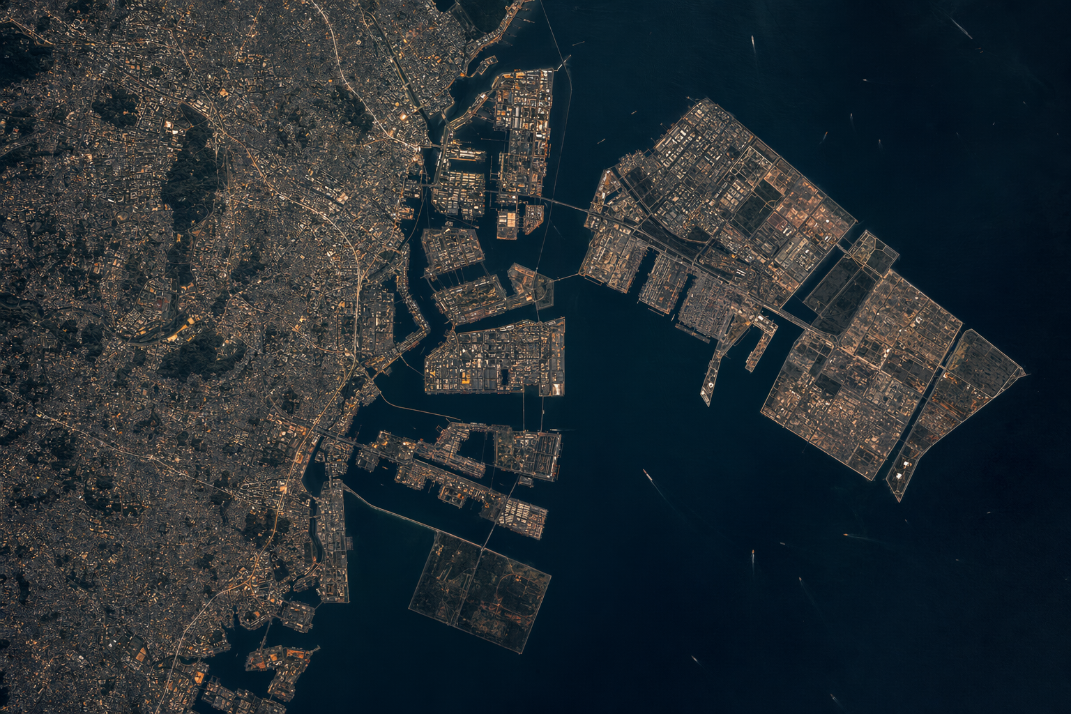
Japan built more offshore airport reclamation than any other country. Five projects across five decades constitute the densest record of large-scale marine reclamation for operational infrastructure in existence.
Kobe Port Island
Kobe had no room for a container terminal on its natural coastline. The city’s solution, beginning in 1966, was to excavate the Rokko mountain range behind Kobe and move it into Osaka Bay. The fill material, called Masado, is decomposed granite with a grain size of 0.2 to 6 mm, roughly 37 to 63% gravel by weight. It was transported to the reclamation site by conveyor belt and barge. Phase 1 ran from 1966 to 1981 and produced a 436 ha island. Phase 2 added 390 ha to the south. The combined Port Island and Rokko Island (580 ha, 1972-1992) represent approximately 1,016 ha of reclaimed area in Kobe Harbor.
On January 17, 1995, the Great Hanshin Earthquake (Mw 6.9) struck. Port Island suffered pervasive liquefaction despite the Masado’s well-graded coarse gradation, which had been considered moderately liquefaction-resistant by standard criteria. Actual ground motions exceeded design thresholds by roughly a factor of four. Lateral displacement of quay walls averaged 2 to 3 m with maximums of 3 m. Grabens formed behind displaced walls at 4 m depth and 30 m width. All but 6 of approximately 187 berths suffered severe damage. Total damage: 1 trillion yen. Kobe fell from sixth to seventeenth globally as a container port, a position it never recovered.
The 1995 earthquake forced a fundamental revision of Japanese seismic design standards for reclaimed land. All major post-1995 offshore reclamation requires explicit liquefaction mitigation and updated acceleration design values.
Kansai International Airport
Kansai (KIX) is the canonical settlement dataset in offshore island engineering, and one of the more instructive lessons in geotechnical prediction failure.
The site is in Osaka Bay, 5 km offshore and 38 km southwest of Osaka Station, in 18 m of water. Below the seabed lies approximately 20 m of Holocene clay holding roughly 70% water by volume, underlain by alternating Pleistocene clay and sand-gravel layers extending 400 m below the seafloor. The Pleistocene (diluvial) deposits are the primary driver of ongoing settlement. The pre-construction design prediction for Island I total settlement was 5.7 m (optimistic estimate).
Island I construction ran from 1987 to 1994. The seawall consists of 69 steel caisson chambers, each 22 m tall and 22 m in diameter, weighing approximately 200 tonnes. Three mountains were excavated to provide approximately 21 million m3 of seawall rock. Inside the completed seawall, 180 million m3 of fill was deposited. Ground improvement used approximately 1 million sand drains, each 40 cm in diameter, driven through the Holocene clay on a 2.5 by 2.5 m grid, plus sand compaction piles (SCP). The drains accelerated Holocene clay consolidation so that this layer’s settlement was essentially complete within one year of fill placement.
The Pleistocene contribution was not treatable. KIX Island I opened September 4, 1994. Cumulative settlement as of December 2024: 13.66 m. Settlement before opening: 9.82 m. The Holocene layer behaved as designed; all ongoing long-term settlement is attributable to Pleistocene clay exhibiting anomalous compression that continues even under loads below the preconsolidation pressure, a behavior that cannot be captured by standard Terzaghi consolidation theory. The island is projected to reach sea level in June 2067.
Terminal 1, designed by Renzo Piano and stretching 1.7 km (the longest airport terminal in the world at opening), rests on 900 individually adjustable support columns. Steel plates inserted beneath hydraulic jacks restore level as differential settlement occurs. The adjustment is a permanent maintenance activity.
Island II was built between 1999 and 2007, with 1.2 million sand drains and additional deep mixing. Its fill volume was 250 million m3. Despite improved geotechnical knowledge and more intensive ground improvement, Island II has settled more than Island I: 17.47 m cumulative as of December 2024, at a current rate of 21 cm per year. Island II’s seabed geology is deeper and softer. Deeper and softer input geology dominates over improved technique. Island II is projected to reach sea level in January 2056. Its construction cost ¥910 billion, saving ¥650 billion from a ¥1,560 billion estimate through procurement improvements.
Total KIX investment as of 2008: approximately US$20 billion. KIX accumulated more than 1 trillion yen in debt by 2015, prompting privatization. In April 2016, a consortium of Vinci Airports and Orix assumed management under a 44-year concession through 2060.
Chubu Centrair
Chubu Centrair opened February 17, 2005, on a 470 ha island in Ise Bay, 35 km south of Nagoya. It was built and is operated by Central Japan International Airport Co. (CJIAC), a joint venture with approximately 40% private equity, a substantially higher private share than KIX. Toyota Motor Corporation was among the primary advocates. The initial budget was ¥768 billion. Actual expenditure was ¥668 billion, a ¥100 billion underrun achieved through private-sector cost discipline in construction management. The seabed at Ise Bay was shallow and geologically stable relative to Osaka Bay, permitting direct revetment construction without the massive Holocene clay treatment program KIX required. Penta-Ocean Construction was the major contractor, as it was at KIX Island I and multiple Singapore projects.
Haneda D-Runway
Haneda required a fourth runway to increase annual movements from 285,000 to 407,000. The site was at the mouth of the Tamagawa River. A conventional fill island would have obstructed river flood flows. The solution was a hybrid structure: a conventional reclamation section (fill volume approximately 52 million m3, SCP ground improvement of the seabed clay, fill thickness approximately 41 m from seabed to runway surface) combined with a 52 ha pile-supported steel-jacket platform of 198 prefabricated jackets on 1,165 steel piles. The jacket section produced less than 8% impedance to river flood flow, the hydraulic criterion that drove the hybrid design choice. Runway length: 2,500 m. Construction ran from March 2007 to October 2010, completing on schedule in 3.5 years. The primary contractor consortium was led by Kajima Corporation.
Tokyo Bay
Tokyo Bay contains approximately 249 km2 of reclaimed land as of 2012, representing roughly 15% of the original bay area. The accumulation spans more than 400 years, from Edo-period drainage works and defense batteries through 2010s infrastructure. The 1853 Odaiba battery construction, triggered by Commodore Perry’s arrival, employed 5,000 laborers who leveled the Gotenyama plateau in Shinagawa for fill and operated 2,000 hauling boats simultaneously. Post-WWII debris from Allied firebombing was systematically pushed into the bay to create land, a disposal method that left geotechnically variable fill still producing differential settlement in 2018, when Toyosu Market opened after contamination remediation costing 86 billion yen.
See reclamation-methods for the sand drain, SCP, and deep mixing taxonomy. See institutions-and-permitting for the NTT-stock-proceeds financing structure of KIX and its concession outcome.
Denmark: Lynetteholm
Lynetteholm is a 275 ha peninsula being built in Copenhagen’s Øresund harbor between Refshaleøen and the Nordhavn district. Construction began January 17, 2022. The Folketing authorized it on June 4, 2021, by 85 votes to 12.
The project is unusual in two respects. First, the fill material is not dredged marine sand but surplus excavated soil from Copenhagen and the Capital Region: metro tunnels, building basements, utility corridors. By & Havn (co-owned 95% by Copenhagen Municipality and 5% by the Danish state) estimates 80 million tonnes of surplus soil over approximately 30 years of filling beginning in the mid-2020s. This inverts the usual cost structure. Instead of paying for fill, By & Havn collects fees from construction contractors for disposal rights. At a 3% real discount rate, projected soil-receipt income is DKK 2 to 2.5 billion in present value, roughly matching the DKK 2.5 billion perimeter construction cost.
Second, the perimeter is not a concrete seawall but a 7 km rock embankment with a sloped profile. The design standard is 2.5 m above mean sea level at the embankment crest, with a wide-and-flat geometry that allows future heightening by adding material to the slope rather than extending a vertical wall. Copenhagen’s RCP8.5 sea-level rise projection is 29 to 162 cm by 2100 (5-95% range); the embankment geometry accommodates the intermediate scenarios and can be adapted for higher projections without demolishing and rebuilding.
Phase 1 perimeter cost DKK 497 million against a DKK 300 million budget, a 67% overrun attributed to steel price spikes and quantity underestimates. Phase 2 contract (Per Aarsleff A/S): DKK 2.15 billion, covering approximately 5.4 km of main embankment and 1.7 km of temporary perimeter. Phase 2 alone requires 3,153,000 tonnes of quarry rock from Norway, transported by sea. Phase 1’s CO2 footprint came in 17.6% below target.
The M5 metro agreement was signed March 28, 2025. Total M5 cost: DKK 22.6 billion (Phase 1 at DKK 18.7 billion, Phase 2 at DKK 3.9 billion). Full infrastructure including the metro: approximately DKK 33.1 billion. M5 Phase 1 is targeted for 2036 (6 stations), Phase 2 for 2045 (3 elevated stations on and near the island). Lynetteholm’s urban program is 20,000 homes and 35,000 residents, 25% public housing, on 2.4 million m2 of residential floor area. The University of Copenhagen calculated a net welfare gain of DKK 20.6 billion in a structural dynamic model capturing housing price effects, commute times, and labor market access through 2090.
The active legal dispute concerns the Kongedybet trench. Øresund connects the North Sea and Baltic via three undersea channels; Kongedybet carries dense saltwater inflow southward while brackish Baltic water flows northward above it. Lynetteholm’s perimeter physically intersects Kongedybet. The Danish Hydraulic Institute assessed the blockage effect at approximately 0.25% reduction in annual saltwater exchange. Deltares, commissioned as independent reviewer at Sweden’s request, validated the DHI calculation as negligible relative to natural variability. Professor Stiig Markager of Aarhus University disputes both the method and the conclusion: the DHI model was calibrated against a single year (2018), a 0.25% annual reduction accumulates over 100 years, and the Baltic’s stressed ecosystem has limited buffering capacity. The Coalition Clean Baltic, representing organizations from all 11 Baltic countries, recommended scaling the island back by approximately one-third.
The injunction application was denied by Østre Landsret on March 22, 2024. The main case on the merits remains pending as of April 2026.
By & Havn’s predecessor model was proven at Nordhavn, where a DKK 20 billion metro and infrastructure investment over 2012-2025 was substantially recouped through land sales, establishing that Copenhagen’s public land-value capture mechanism works at megaproject scale. Lynetteholm is the same mechanism applied to new land rather than brownfield.
See economics-and-value-capture for the By & Havn model and comparisons to Battery Park City Authority. See storm-surge-and-sea-level for Copenhagen’s 1872 design benchmark and the Kongedybet hydrodynamics.
Hong Kong: Chek Lap Kok and the Third Runway
Hong Kong’s two reclamation phases at Chek Lap Kok span 32 years and constitute a complete record of what scale reclamation actually costs across different geotechnical and regulatory contexts.
Original Airport (1992-1998)
Kai Tak Airport had one runway, a 47-degree approach over a densely populated residential district, noise exceeding 105 dB(A) over 340,000 residents, and no room to expand. The Port and Airport Development Strategy study, reported in December 1989, selected Chek Lap Kok on the north coast of Lantau Island. Governor David Wilson announced the Rose Garden Project on October 11, 1989, explicitly as a confidence measure after the June 4 Tiananmen killings had accelerated emigration. China pressed for fiscal limits; the resulting UK-China MOU signed September 3, 1991 capped post-handover debt at HK$23 billion and reserves at not less than HK$25 billion.
The reclamation required converting two islands into a 1,248 ha platform. Chek Lap Kok island itself was approximately 302 ha with a summit of roughly 100 to 122 m above sea level (sources disagree on the exact height). Adjacent Lam Chau island added 8 ha. The combined 310 ha grew to 1,248 ha: a 4x expansion, with 9.38 km2 of seabed reclaimed.
Site preparation contract PAA 201, awarded to Zhen Hua Engineering Company Limited, was at completion the world’s largest and fastest excavation and earth-removal project. Total materials removed or moved: 347 million m3. Of this, approximately 90 million m3 came from island rock and approximately 250 million m3 was marine sand dredged from borrow areas 4 to 45 km distant. Island rock was blown down using 40,000 tonnes of explosives. Peak fill placement: 2 ha per day. Peak material movement: approximately 10 tonnes per second. Platform formation ran from December 1992 to approximately mid-1995, a 2.5-year phase.
The contractor chose fully dredged reclamation over the alternative enclosed-and-drained approach specifically because of the political deadline. The 1997 handover was fixed. Dredging was faster than drainage. The logistics required the largest dredger fleet assembled to that date, with Dutch, Belgian, Australian, Japanese, British, and American contractors operating simultaneously.
The entire Airport Core Programme comprised ten interdependent projects: the airport, Tsing Ma Bridge and the Lantau Link crossing, the Airport Railway, North Lantau Highway, West Kowloon Highway, Western Harbour Crossing, West Kowloon Reclamation (334 ha), Central Reclamation Phase I, and Tung Chung New Town. Original estimate: more than HK$200 billion. Negotiated target: HK$158.2 billion. Final outturn: HK$160.2 billion across 225 contracts. The airport alone cost approximately HK$49.8 billion, roughly USD 6.3 billion at 1998 exchange rates. Guinness World Records recognized it as the most expensive airport project ever built. ConExpo 1999 voted it one of the top ten construction achievements of the twentieth century. HKIA opened July 6, 1998.
Three-Runway System (2016-2024)
By 2012 HKIA was approaching saturation on two runways, handling 55.5 million passengers and 4.07 million tonnes of cargo. The EIA for a third runway was approved November 7, 2014; construction authorized April 29, 2016; construction commenced August 1, 2016.
The 3RS added approximately 650 ha north of the existing platform. But the method was fundamentally different from 1992, for a reason the seabed imposed: the north Lantau sea area within the reclamation boundary had been used since the early 1990s as Contaminated Mud Pits (CMPs), designated disposal areas for dredged contaminated sediment from Hong Kong harbor maintenance and earlier reclamation projects. The CMPs contained heavy metals and persistent organic pollutants including PCBs.
Conventional reclamation would have required dredging out the contaminated mud, mobilizing it, transporting it, and disposing of it elsewhere. Limited receiving capacity remained. Disturbing the material also posed direct water quality risks and PCB mobilization risks to the Chinese White Dolphin habitat at Sha Chau. The EIA mandated deep cement mixing (DCM) as the required ground improvement method over CMP areas.
DCM immobilizes contaminated sediment in place by injecting and mixing cement slurry into soft mud in situ, forming rigid columns that stabilize the ground and prevent contaminant migration. No mud is removed. Target treatment depth: approximately 20 m below seabed. Target 28-day unconfined compressive strength: 800 kPa. The 3RS used 5 main DCM contracts covering 6 areas, with up to 62 DCM rigs operating simultaneously. The primary DCM contractor, a Samsung C&T and Build King joint venture, received approximately USD 340 million. The worst-case contaminant concentrations at water-sensitive receivers under DCM operations were modeled at less than 4% of regulatory criteria values.
This was the largest single application of offshore marine DCM in history. The 3RS also required 100 million m3 of sand fill, which could not come from depleted Hong Kong coastal waters. A framework agreement signed May 2019 with Zhen Hua Engineering, CCCC, and Guangxi Beibu Gulf International Port Group brought sand from Guangxi province, a mainland provincial-government-level supply agreement.
The 3RS total budget is HK$141.5 billion at 2015 prices, approximately USD 18.3 billion. A HK$35 billion loan facility with 21 banks was secured in June 2020. The third runway was commissioned November 25, 2022; the full three-runway system became operational November 28, 2024.
HKIA’s post-3RS design capacity is 120 million passengers per year and 10 million tonnes of cargo per year. In 2024 it handled approximately 53 million passengers and was the world’s busiest cargo airport for the 13th time.
The Chinese White Dolphin population in Hong Kong waters reached a historic low of 32 individuals in 2019, a 30% year-on-year decline attributed to 3RS construction. The 250 mitigation measures in the EIA and the designation of the Brothers Marine Park as compensatory habitat have not reversed the population decline.
The 3RS illustrates a principle visible across the corpus: method selection in reclamation is often determined by what is in the ground, not by engineering preference. Clean seabed allows dredge-and-fill. Contaminated seabed forces in-situ treatment. And the contamination in the seabed was created by earlier rounds of the same reclamation activity, meaning each generation’s choices constrain the next generation’s options.
See reclamation-methods for the DCM taxonomy and the comparison with dredge-and-replace. See institutions-and-permitting for the Hong Kong EIA process and the contaminated mud regulatory framework.
China: Spratly Islands
Between late 2013 and late 2016, China reclaimed approximately 1,300 ha of new territory across seven reef features in the Spratly archipelago of the South China Sea. The campaign was not a single project. It was seven simultaneous construction operations on reef features scattered across 425,000 km2 of ocean, coordinated by CCCC subsidiaries using cutter-suction dredgers operating continuously.
Scale and Features
The three largest features are Mischief Reef (5.58 km2), Subi Reef (3.95 km2), and Fiery Cross Reef (2.74 km2). The remaining four, Johnson South, Gaven North, Cuarteron, and Hughes, are smaller. Total reclaimed area across all seven: approximately 12.8 km2. In June 2015, China had created more than 810 ha of new land in 18 months, more than all other Spratly claimants combined had reclaimed over the preceding 40 years.
Method
The primary instrument was the Tian Jing Hao, a cutter-suction dredger 127.5 m long, built in 2010, operated by Tianjin Dredging Company. Rated output: 4,500 m3 per hour. Maximum pump range: 6 km. Maximum dredging depth: 30 m. AIS tracking confirmed the Tian Jing Hao visited at least five reefs during a 193-day operational period between September 2013 and June 2014. It won China’s National Science and Technology Progress Award in 2019 for this work.
The construction sequence reconstructed from satellite imagery: floating breakwaters and pontoons defined the fill perimeter; the cutter-suction dredger excavated the reef flat and lagoon bed; slurry traveled hydraulically through floating pipelines to the fill area; trailing suction hopper dredgers used rainbowing (pumping fill through a nozzle at 30-degree elevation, projecting slurry up to 80 m onto the fill) to build the surface above the waterline; rock armor revetments were then placed around the perimeter; hardstand followed, then facilities.
The fill material was the reef itself: carbonate sand and rubble from disaggregated live coral reef and lagoon sediment. Fine carbonate material compacts poorly and causes consolidation challenges that are not fully documented in publicly available sources. Total estimated fill volume: 40 to 50 million m3, derived from area and fill depth geometry and not independently verified in peer-reviewed literature.
Ecological Damage
The 2016 PLOS Biology study by Mora et al. analyzed Landsat 8 imagery from February 2014 to May 2015. Reef area destroyed: approximately 11.6 km2. That represents 26.9% of the total pre-reclamation Spratly reef area. Pre-reclamation coral cover averaged approximately 64% across these reefs, more than double the Indo-Pacific average of below 25%. Combined turbidity plumes from CSD operations exceeded 4,300 km2. At Mischief Reef alone, satellite backscatter increased up to 350% in surrounding waters at peak construction, with sediment plumes exceeding 250 km2.
Dredging from comparable sites shows no complete ecological recovery after 30 years. Marine scientist Edgardo Gomez estimated direct reef destruction of 311 ha with annual economic losses of at least USD 110 million in reduced regional fish catch.
Legal Status
The Permanent Court of Arbitration in the Philippines v. China case (PCA Case No. 2013-19) issued a 501-page unanimous award on July 12, 2016. Key findings: all seven Spratly features are legally rocks or low-tide elevations under UNCLOS Article 121; reclamation cannot upgrade their legal status because UNCLOS is concerned with the feature in its natural condition; China’s nine-dash line claim to historic rights within the dashes has no legal basis under UNCLOS; China’s island-building activities breached UNCLOS environmental protection obligations.
China’s official response, issued the same day: “The award is null and void and has no binding force. China neither accepts nor recognizes it.”
Militarization
In September 2015, Xi Jinping stated at the White House that China “does not intend to pursue militarization” of the Spratly Islands. The following military infrastructure was confirmed by satellite imagery and US intelligence reporting:
The three largest reefs received 3,000 m class runways capable of all PLA-AF and PLA-N fixed-wing aircraft. In April 2018, YJ-12B anti-ship cruise missiles (295 nm range) and HQ-9B surface-to-air missiles (160 nm range) were confirmed deployed to all three major reefs. As of October 2022, more than 5,000 Chinese personnel were stationed across South China Sea features. Electronic warfare and ISR upgrades continued through 2025. The four smaller features received anti-aircraft guns, close-in weapon systems, helipads, and radar installations.
What began as reef-flat reclamation with carbonate fill now supports three fully equipped military air bases and associated naval facilities in an area over which China holds no recognized sovereign territory under international law.
The Successor Vessel
The Tian Kun Hao, launched November 2017 and commissioned June 2018, is the successor platform. Length 140 m, total installed power 25,843 kW, dredging capacity 6,000 m3 per hour, maximum pump range 15 km, maximum dredging depth 35 m. It represents the direction of Chinese dredging industrial capacity, which has no Western peer in CSD class. Vietnam has since begun its own reclamation campaign using the same cutter-suction method, reaching approximately 70% of China’s total Spratly area by early 2025.
See industrial-base for the Chinese dredge fleet in context of the global industry. See reclamation-methods for rainbowing and CSD pump-range constraints.
What the Precedents Establish
Each program answers a different question.
Maasvlakte 2 establishes the economic case at port scale: EUR 900 million at 30-year EIB rates, serviced by long-term industrial leases on new land, producing EUR 548 million EBITDA per year at the port level. The financing closed on the project’s own revenue projections.
Jurong Island establishes the petrochemical-cluster model: public land authority holds the reclaimed substrate, industrial tenants fund their own facilities, lease revenues recoup reclamation costs, cumulative tenant investment exceeds the cost of production by a factor of several.
Tuas Mega-Port establishes automation at full terminal scale and shows that consolidating scattered urban port facilities onto a single reclaimed platform simultaneously produces port efficiency and frees valuable urban waterfront for redevelopment. The freed land is a second revenue stream.
Kansai establishes the settlement problem in irreducible form. When the Pleistocene clay is thick and compressible, no known ground treatment resolves the long-term subsidence. You are committing to centuries of monitoring and maintenance. The gap between prediction and outcome, a factor of 2.4 on Island I (5.7 m predicted, 13.66 m actual), is the most dramatic settlement miscalibration in modern geotechnical engineering. Island II, built with better knowledge and more drains, settled more than Island I because the geology was worse.
Lynetteholm establishes two things: that surplus soil disposal can invert the reclamation cost structure so the fill becomes revenue rather than expense, and that sloped rock embankments can be designed for adaptability rather than fixed resistance, allowing future raising as sea-level projections update.
Chek Lap Kok (original) establishes that a political deadline can drive method selection as decisively as any engineering criterion: the choice of fully dredged over enclosed-and-drained was made because the 1997 handover was fixed. Chek Lap Kok (3RS) establishes that legacy contamination from previous reclamation directly constrains subsequent reclamation method, and that DCM at 650 ha scale works as an alternative to dredge-and-replace.
The Spratlys establish the speed envelope when institutional constraints are set aside: 1,300 ha across seven features in roughly 30 months, by a single national industrial actor using cutter-suction dredging without environmental review, compensation, or legal limitation. The pace came at a cost measured in 11.6 km2 of destroyed reef, 4,300 km2 of turbidity impact, and zero recognized maritime entitlement.
The engineering stack across these programs is catalogued in reclamation-methods. The financing structures and economic closure mechanisms are in economics-and-value-capture. The institutional and permitting paths are in institutions-and-permitting. US programs from Battery Park City to Louisiana CPRA are in us-precedents.