Florida is the test case because it is the hardest case. It has more hurricane landfalls than any other state, 112 since 1851 by NHC records. Its most-populated coast, the Gold Coast from Palm Beach to Miami-Dade, sits on a shelf so narrow that beach-quality sand sources are largely exhausted. Its insurance market has shed six carriers to insolvency in a single year, 2022, and has seen Citizens Property Insurance Corporation balloon to 1.42 million policies at peak, roughly 19 percent of the statewide homeowners market. Its most ecologically constrained water, the Florida Keys, is losing critical-shelter infrastructure to one foot of sea-level rise by projections of the Southeast Florida Regional Climate Change Compact (2019).
The state is simultaneously running the most sophisticated beach nourishment program in the United States, spending more than $1.55 billion from state trust funds since 1998, and watching that program approach its geological limits in the south while performing well in the north. The gap between the two situations is not a policy choice. It is geology.
This document applies the full territorial-engineering framework to Florida by region, then examines what a pilot district would structurally require to move from analysis to construction. The terms used throughout, including reclamation, nourishment, and armoring, follow the definitions in ontology. The physical system those methods operate inside is developed in coastal-morphodynamics and sediment-as-infrastructure. The precedent base is in global-precedents and us-precedents.
The five-region problem
Florida’s coast does not have a single engineering situation. It has five, differentiated by shelf geometry, sediment supply, storm exposure, and existing regulatory infrastructure. Every generalization about Florida coastal engineering that fails to distinguish them is wrong in at least two of the five.
| Region | Sandy Shore (mi) | Shelf Width | Depth at 5 mi offshore | Primary Sand Type | Design Storm Benchmark |
|---|---|---|---|---|---|
| Gold Coast (SE Atlantic) | ~60 | 5-20 km | 20-40 m | Offshore oolitic/carbonate | HVHZ 175 mph; Andrew 1992 |
| Florida Keys | ~35 (fragmented) | <5 km (Atlantic side) | 10-30 m (Hawk Channel) | Coral carbonate, no silica | 1935 Labor Day 892 mb |
| SW Gulf (Collier-Pinellas) | ~200 | 120-180 km | 6-15 m | Fine quartz/carbonate mix | Ian 2022, 10-15 ft surge |
| Panhandle | ~100 | 30-80 km | 20-35 m | Fine white quartz | Michael 2018 Cat 5, 14-19 ft surge |
| NE Florida (Atlantic) | ~150 | 50-100 km | 8-20 m | Quartz shoal sands | Rare direct landfalls |
The shelf geometry column is the primary driver of both surge vulnerability and dredging economics. Narrow deep shelves, like the Gold Coast, give offshore dredge vessels room to work but produce little sand. Broad shallow shelves, like the West Florida Shelf at 120-180 km off Tampa Bay, create severe surge amplification but hold abundant sand at exploitable depths. The Panhandle’s 30-km narrowing at DeSoto Canyon is the pivot case: deep enough for efficient dredging, exposed enough for Category 5 landfalls.
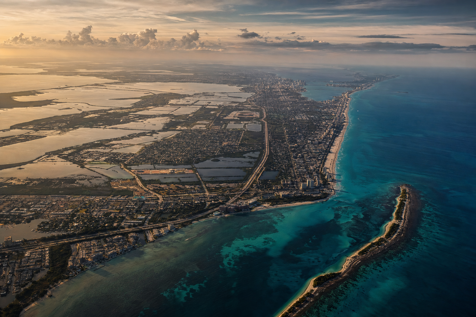
Gold Coast: SE Florida (Palm Beach to Miami-Dade)
The Gold Coast produces the clearest design constraint in the state. More than six million residents in Miami-Dade, Broward, and Palm Beach counties are packed onto a coastal strip between the Everglades and the Atlantic, fronted by a barrier island chain rarely more than one mile wide and separated from the mainland by the Atlantic Intracoastal Waterway and, in Miami-Dade, Biscayne Bay. The continental shelf drops to 20-40 meters depth within 5 miles of shore. The Florida Reef Tract, the third-largest barrier reef system on Earth, runs 270 kilometers from Fowey Rocks to the Marquesas Keys through the near-shore zone, with staghorn and elkhorn coral designated as ESA-threatened critical habitat.
The traditional nearshore sand borrow areas in state waters are exhausted by the BOEM/FDEP cooperative assessment (agreement MC1400004). Miami Beach has been nourished continuously since 1981, cumulative cost above $200 million, at unit costs of $30-50 per cubic yard, reflecting the growing pipe distances from viable sand sources. BOEM-funded surveys have identified OCS sediment in federal waters, but these are more distant and at greater depths, translating directly to higher mobilization costs. The shortage is geological, not political. The shelf does not produce sand on a human timescale.
Design storm exposure is the highest in the state. The High Velocity Hurricane Zone designation under the Florida Building Code 2023, 8th Edition, covers all of Miami-Dade and Broward counties, with Risk Category II design wind speeds of 175 mph (3-second gust, ASCE 7-22). Hurricane Andrew’s 1992 landfall at Homestead produced the institutional response that created the modern HVHZ: over 25,000 homes destroyed, $27 billion in 1992 dollars, and the subsequent collapse of several Florida domiciled insurers. A repeat of the 1926 Great Miami Hurricane, with a direct Miami track as a Category 4-5, is estimated by catastrophe modelers at $100 billion or more in insured losses at today’s exposure values.
For reclamation, the Gold Coast presents a specific geometry. The value of new frontage is highest in the state on any per-acre measure; PortMiami and Port Everglades represent two of the most active container and cruise ports on the US East Coast. PortMiami’s 2015 deepening from 42 to 50 feet, $205 million, positions it as the closest US port to the Panama Canal capable of accommodating fully loaded post-Panamax vessels. Port Everglades has a General Reevaluation Report underway for deepening from 42 to 48-50 feet. Both ports are operating against physical channel constraints under existing geometry.
A reclamation district anchored to PortMiami’s outer harbor, using the protected water of Biscayne Bay as the inner lagoon and a new outer barrier belt to the east, would follow the layered-barrier topology described in the-map-is-not-sacred. The fill body would not source from the depleted shelf. Imported carbonate fill from Bahamian banks is a demonstrated alternative at the scale of regional nourishment projects. For port-adjacent reclamation, construction-grade material from the OCS, not subject to beach-grade specification, would be eligible at lower unit costs than beach nourishment. The ESA constraint is real and would require a full Section 7 consultation with programmatic coverage, similar to the South Atlantic Regional Biological Opinion for dredging operations.
Pilot anchor: PortMiami outer harbor, Biscayne Bay protected water. Fill sourcing: imported OCS material for structure; Bahamian carbonate for beach perimeter if required. Design freeboard: minimum 5.7 m NAVD88 for 50-year project life under NOAA Intermediate sea-level rise scenario for Gulf-equivalent Gulf Coast exposure. Confidence level: Plausible, contingent on ESA coral consultation and sovereign submerged land conveyance from the Board of Trustees.
Florida Keys: Monroe County
The Keys occupy a unique position in the Florida coastal inventory and a singular position in the risk register. They are not barrier islands in the siliciclastic sense. The Upper Keys from Key Largo to Marathon are Key Largo Limestone, fossilized Pleistocene coral reef, 50-174 feet thick based on well borings. The Lower Keys from Big Pine Key to Key West are Miami Oolite. There is no silica sand and no viable sand nourishment substrate. The Florida Keys National Marine Sanctuary covers approximately 9,600 square kilometers and requires permits for essentially any structure or fill.
The 1935 Labor Day Hurricane, with central pressure of 892 mb and sustained winds near 185 mph, the most intense hurricane ever to strike the continental United States by central pressure, destroyed the Florida Overseas Railway. It produced storm surge of 18-20 feet at Upper Matecumbe Key. US-1 (Overseas Highway, 204 km) is the sole land connection and the sole evacuation route for approximately 80,000 year-round residents. Any significant inundation or structural failure severs land access entirely.
The Southeast Florida Regional Climate Change Compact’s 2019 projection for the region is 10-17 inches of sea-level rise above year-2000 levels by 2040. At one foot of sea-level rise, 75 percent of Monroe County hospitals, 65 percent of schools, and 71 percent of emergency shelters become inundated, per Compact analysis.
For territorial engineering, the Keys present the following design envelope. Conventional sand nourishment is incompatible with carbonate substrate and precluded by the FKNMS. Hard armoring of the Overseas Highway corridor is the more tractable intervention, framed within the CCCL and Section 161, Florida Statutes. New land construction on the carbonate limestone substrate presents a different problem than open-water reclamation: the substrate is not soft marine clay requiring PVD or DCM ground improvement per the treatment in coastal-morphodynamics. It is competent rock, suitable for direct caisson or sheet-pile perimeter construction at shallower seabed depths. However, any fill within the FKNMS would require Sanctuary coordination beyond the standard USACE/FDEP/BOEM permit stack.
The highest-leverage intervention in Monroe County is not reclamation but elevation. The Galveston model, 16.3 million cubic yards of hydraulic fill raising 500 city blocks by up to 17 feet between 1902 and 1904 at roughly $140 million in current dollars, is the direct precedent. The Keys have insufficient land width for the grade-raising technique as applied at Galveston, but selective elevation of the US-1 corridor and critical infrastructure nodes is within demonstrated engineering capacity.
Assessment: The Keys are the lowest-priority region for reclamation and the highest-priority for armoring and selective elevation. The FKNMS constraint, the carbonate-only substrate, and the absence of a sand nourishment pathway collectively remove Keys from reclamation candidates. They are addressed here for completeness and because the insurance and evacuation risk makes them a state-level policy priority regardless.
SW Gulf: Collier County to Pinellas County
The Southwest Gulf coast is the classic Florida barrier-island coast. Lee, Sarasota, Charlotte, Manatee, and Pinellas counties front a nearly continuous chain of low barrier islands, generally 0.1 to 0.5 miles wide and 0-10 feet in elevation, backed by a series of bay and estuary systems including Charlotte Harbor, Sarasota Bay, and Tampa Bay. The West Florida Shelf is among the broadest continental shelves in North America. At Tampa Bay the shelf runs approximately 120 km; at Charlotte Harbor and the Big Bend the width reaches 180 km.
Shelf width is the dominant design parameter for this region, and it operates in both directions. The broad shallow shelf holds abundant sand at exploitable depths, 6-15 meters at 5 miles offshore, at volumes sufficient for large-scale reclamation fill. The same broad shallow shelf is a severe surge amplifier. Hurricane Ian made landfall near Cayo Costa (Lee County) on September 28, 2022 as a Category 4 with 150 mph winds. Storm surge of 10-15 feet was recorded across Fort Myers Beach and Bonita Beach, with high-water marks reaching approximately 16 feet in spots. The Fort Myers NOAA gauge peaked at 7.26 feet, a record, though this understates the full inundation in the most impacted zones. Ian generated estimated total losses of approximately $112 billion, making it the costliest hurricane in Florida history and third-costliest in US history behind Katrina and Harvey (NHC Tropical Cyclone Report, AL092022). In Lee County alone, 52,514 structures were impacted and 5,369 destroyed.
The physics of surge on the West Florida Shelf operates differently from the Gold Coast. The broad, flat shelf geometry allows surge to propagate far inland with minimal depth attenuation. A layered-barrier extension in this region functions as a surge absorber by design. The outer belt reduces energy before it reaches the mainland. The protected water inside functions as a surge reservoir that can be designed with controlled inlets rather than open bay exposure.
Tampa Bay presents the Port of Tampa infrastructure anchor. The main shipping channel to the Port of Tampa is dredged to 43 feet. Tampa Bay as a whole is approximately 1,000 square kilometers, the largest open-water estuary in Florida. A reclamation district anchored to the Port of Tampa outer harbor, using the bay’s existing protected water and a new outer perimeter belt on the Gulf side, would follow the layered topology while also reducing Tampa Bay’s surge exposure for the greater metropolitan area.
Seagrass beds and sea turtle nesting are the primary ESA constraints on this coast. Hopper dredging is typically prohibited May 1 through October 31 in most Florida counties under the South Atlantic Regional Biological Opinion (SARBO, July 31, 2020), which covers USACE and BOEM dredging and nourishment from North Carolina to the Florida Keys. Beach fill material must not harden to prevent sea turtle nesting interference. Construction season windows are generally November through April, which aligns with the pre-hurricane-season period and gives roughly 6 months of construction time per year.
The CERP footprint (WRDA 2000, as reauthorized through WRDA 2024) covers the South Florida Ecosystem from Lake Okeechobee through Florida Bay. The Everglades freshwater and mangrove system merges directly into the coast between Collier County and northern Monroe County. Any reclamation in Collier County waters at the south end of this region would require CERP-consistency review and coordination with the South Florida Water Management District.
Pilot anchor: Port of Tampa outer bay, with Gulf-side outer belt. Fill sourcing: West Florida Shelf OCS sand, abundant at exploitable depths. Design freeboard: minimum 5.7 m NAVD88 for Gulf Coast 50-year project life. The broad shallow shelf means construction vessels would work in 6-15 meter water depths, within the operating envelope of mid-tier trailing suction hopper dredgers. Confidence: Plausible. The primary constraint is CERP coordination in the south, seagrass survey compliance throughout, and inlet stability analysis for Tampa Bay’s tidal prism under any perimeter modification.
Panhandle: Apalachicola Bay to Pensacola
The Florida Panhandle is geologically distinct from the rest of the state’s Gulf coast. The barrier islands, including Perdido Key, Pensacola Beach, Okaloosa Island, Destin, Panama City Beach, and Mexico Beach, are composed of nearly pure quartz sand derived from the Appalachian highlands via the Apalachicola-Chattahoochee-Flint river system. The result is the “Emerald Coast,” white sand beaches with visible-bottom green-to-turquoise water, a physical signature produced by high quartz purity and low heavy-mineral content.
The continental shelf here is much narrower than the West Florida Peninsula. At DeSoto Canyon, east of Pensacola, the shelf narrows to approximately 30 km and the shelf break occurs near the 40-meter isobath. At 5 miles offshore from Pensacola Beach, typical depths are 20-35 meters, comparable to the Atlantic conditions but with Gulf wave climate. Deeper water closer to shore means larger dredge vessels can operate within shorter pipe distances than the West Florida Shelf. This is a construction logistics advantage for reclamation at scale.
Hurricane Michael made landfall near Tyndall Air Force Base and Mexico Beach (Bay County) on October 10, 2018 as a Category 5 storm, the strongest hurricane ever to strike the Florida Panhandle. Sustained winds were 140 knots (160 mph) at landfall; central pressure 919 mb, third lowest for a US landfalling hurricane since 1900. Storm surge at Mexico Beach ranged from 9-14 feet per NHC analysis, with USGS high-water marks inside buildings reaching 17-19 feet AMSL, suggesting still-water surge exceeded the NHC field analysis. In Mexico Beach (population approximately 1,200), 809 of 1,692 buildings were destroyed. Total US damage approximately $25 billion. Tyndall Air Force Base sustained catastrophic damage across its entire installation and was subsequently rebuilt.
Michael’s path illustrates the Panhandle’s distinct risk profile. The storm underwent rapid intensification from Category 3 to Category 5 in 24 hours, a 45 mph increase, over record-warm Gulf of Mexico sea surface temperatures. The NHC underpredicted this rate significantly. Rapid intensification is on average 50 percent more likely during marine heatwave conditions (Nature/Communications Earth and Environment, 2024), and 70 percent of hurricanes causing at least $1 billion in US damage since 1980 underwent rapid intensification (Climate Central 2023).
The Panhandle coast has three military installation anchors: Naval Air Station Pensacola, Eglin Air Force Base (the largest Air Force base in the world by area), and Tyndall AFB. Defense deepwater access is a separate demand for new frontage from tourism and residential use, and it connects to the industrial-base argument developed in industrial-base. Tyndall’s post-Michael reconstruction provides a demonstration of large-scale installation rebuild on a coastal site; the associated planning for hardened perimeter design is an existing USAF decision already in execution.
Apalachicola Bay at the eastern end of the Panhandle is the most ecologically constrained water in the region. Historically supplying 90 percent of Florida’s oyster harvest, the bay’s fishery has been severely damaged by freshwater management decisions on the Apalachicola-Chattahoochee-Flint river system and the 2010s drought. Any reclamation in Apalachicola Bay waters would face both ESA constraints and strong state interest in oyster fishery recovery.
Pilot anchor: Tyndall AFB perimeter or Pensacola Bay outer defense district. The defense access use case reduces dependence on speculative civilian absorption and aligns with USACE civil and military programs under WRDA and the Defense Base Act. Fill sourcing: Panhandle quartz sand from OCS shoals, which are accessible at 20-35 meter depths within short pipe runs of DeSoto Canyon. Confidence: Plausible for a defense-oriented district; the regulatory path runs through DoD coordination channels that compress civilian permitting timelines for national-security-designated projects.
NE Florida: Georgia border to Daytona Beach
Northeast Florida is the region most structurally suited to conventional nourishment and limited reclamation among Florida’s five coastal zones. The continental shelf here is 50-100 km wide on the Atlantic side with a more gradual offshore slope than SE Florida. Offshore sand bodies, characterized by Meisburger and Field (1975) and subsequent BOEM/FDEP cooperative surveys, include numerous accessible borrow areas at 8-20 meter depths within short pipe runs. BOEM has authorized a combined NE Florida program covering Ponte Vedra, Vilano, Flagler, and St. Augustine at up to 11 million cubic yards, restoring nearly 17 miles of Atlantic coast.
JAXPORT is the infrastructure anchor. The Jacksonville Harbor Deepening Project, completed in May 2022 at $420 million, deepened the 11-mile federal channel from 40 to 47 feet. It was the first US East Coast port deepening funded by combined local, state, federal, and private dollars (USACE Jacksonville District, 2022). JAXPORT is now the first US East Coast port of call for fully loaded post-Panamax vessels, supporting 15,000 jobs and $31 billion annual economic impact. The deepening generated dredged material from the St. Johns River channel that constitutes a potential beneficial reuse stream for adjacent Atlantic coast beaches.
NE Florida’s hurricane exposure is markedly lower than the other four regions. The region rarely takes direct landfalls; most Atlantic-basin storms track in ways that threaten but do not make landfall. The lower design storm baseline translates to lower freeboard requirements and reduced armor specification compared to the Gulf coast or HVHZ. The 100-year event design standard produces lower surge projections than the SW Gulf or Gold Coast.
Barrier islands along this coast, Amelia Island, Talbot Islands, Jacksonville Beaches, Ponte Vedra Beach, Crescent Beach, are moderate width (0.5-1.5 miles) with better-developed dune systems than SE Florida barriers. This gives more working room for outer-belt placement without immediate conflict with existing structures.
The ESA constraints are lighter than the reef-constrained Gold Coast, though sea turtle nesting (loggerhead, green, and other species) is active on NE Florida beaches and triggers the same SARBO construction season restrictions (November through April work windows for hopper dredging near nesting beaches). Atlantic sturgeon, West Indian manatee, and North Atlantic right whale are the relevant listed species for offshore operations.
Pilot anchor: JAXPORT outer harbor extension, St. Johns River estuary. The harbor deepening is complete; the channel can now support JAXPORT’s post-Panamax positioning. A reclamation district anchored to JAXPORT’s outer harbor would convert channel dredge spoil to beneficial reuse, extend port capacity without additional channel deepening (which has effectively reached geological limits at 47 feet), and produce protected water on the estuary side. Fill sourcing: NE Florida OCS shoals plus beneficial reuse from JAXPORT maintenance dredging, at estimated $10-25 per cubic yard delivered. Confidence: Plausible. Of all five regions, NE Florida has the best combination of accessible OCS sand, lower hurricane exposure, existing port authorization, and manageable ESA constraint.
Sediment: cross-regional sourcing summary
The sourcing picture by region consolidates to a table. The sediment-as-infrastructure document establishes the full grade hierarchy from beach-grade to construction fill.
| Region | Beach-Grade Source | Fill Constraint |
|---|---|---|
| Gold Coast | OCS (distant, $30-50/CY), upland mining (Jahna) | Reef tract ESA corridor; shelf exhaustion in state waters |
| Florida Keys | None viable | FKNMS; no silica sand geologically present |
| SW Gulf | West Florida Shelf OCS at 6-15 m depth | Seagrass ESA; CERP coordination |
| Panhandle | DeSoto Canyon OCS shoals, fine quartz | Apalachicola Bay ecological sensitivity |
| NE Florida | NE OCS shoals at $10-25/CY; JAXPORT beneficial reuse | Sea turtle season windows (Nov-Apr work) |
Two cross-regional points bear on any pilot district. First, BOEM has signed 22 Florida leases out of 58 national OCS sand leases since 1995. The OCS inventory is most complete in NE Florida and least complete in SE Florida, where coral constraints limit survey corridors. A Gold Coast reclamation district would require new OCS characterization surveys before a borrow area lease could be structured. Second, USACE dredges approximately 210 million cubic yards per year nationally (Florez 2025), with current beneficial reuse running 30-40 percent against a target of 70 percent by 2030. Florida’s port deepenings, PortMiami 5 million cubic yards of bay-bottom placed in 2015 and JAXPORT channel material from 2022, represent beneficial reuse streams that can supplement OCS sand for adjacent fill projects at below-market unit costs.
Insurance, risk, and what reclamation changes
Florida represents approximately 30-50 percent of US insured catastrophe hurricane loss potential in catastrophe models, concentrated in the Gold Coast. Ian 2022 generated insured losses of $53-67 billion by modeler estimates, triggering the insolvency of United Property and Casualty in early 2023, after six Florida-domiciled carriers already failed in 2022. Citizens Property Insurance Corporation peaked at 1.42 million policies in October 2023 and required a 2024 reinsurance purchase of $3.6 billion.
A layered outer barrier belt has a measurable effect on modeled loss at the county level if it intercepts surge before it reaches the insured exposure. The outer belt does not eliminate surge; it absorbs the first fraction of wave and surge energy in sequence consistent with the Sallenger storm-impact scale (see coastal-morphodynamics). The reduction in peak surge at the mainland is a function of the depth and geometry of the belt, and is quantifiable through XBeach or Delft3D modeling as part of permit-phase engineering.
NFIP Risk Rating 2.0, in full implementation since April 1, 2023, prices Florida’s 1.7 million policies covering approximately $440 billion in structures using property-specific variables: distance from water, flood frequency, foundation type, and lowest floor elevation relative to BFE. A reclaimed district with engineered freeboard of 5.7 m NAVD88 or above reduces the distance-from-water and inundation-frequency variables for structures built within it, producing lower Risk Rating 2.0 premiums than the unprotected mainland in the same county. The full catastrophe modeling and insurance framework is in risk-and-insurance.
The regulatory stack in Florida
Florida’s coastal regulatory environment is layered more densely than most states, which is both a constraint and, in one important respect, an asset.
| Instrument | Authority | Key Requirement for Reclamation |
|---|---|---|
| CCCL Program | §§161.052-161.085, F.S.; FAC 62B-33 | Permit required for construction seaward of CCCL in 25 coastal counties |
| Sovereign Submerged Lands | Art. X §11, FL Const.; §253.141, F.S. | Board of Trustees must convey submerged land lease or title for any filled area |
| Ch. 161 Beach and Shore Preservation | Florida Statutes Ch. 161 | FDEP permit for fill; SBMP compliance |
| Peril of Flood Act | SB 1094 (2015); §163.3178(2)(f), F.S. | SLR addressed in all coastal comprehensive plans; AAA designation available |
| Resilient Florida Program | SB 1954 (2021); §380.093, F.S. | Grant program for vulnerability assessment and adaptation; $640M initial appropriation |
| Coastal Zone Management | CZMA, 16 U.S.C. §1451 | Federal consistency review for any OCS activity affecting FL coastal zone |
| USACE Section 404 | Clean Water Act | Individual permit required for fill in waters of the US; follows NEPA EIS ROD |
| ESA Section 7 | Endangered Species Act | Formal consultation with NMFS/USFWS for any likely-to-adversely-affect listed species |
| SARBO (2020) | Programmatic Biological Opinion | Covers USACE/BOEM dredging from NC to FL Keys if Project Design Criteria met |
| BOEM Marine Minerals | OCSLA | Lease required for OCS sand extraction beyond 3 nm |
| Offshore Wind Prohibition | §377.708, F.S. (2024); Trump EO Jan 2025 | No wind structures in state or federal waters; does not affect reclamation |
The sovereign submerged lands constraint under Article X, Section 11 of the Florida Constitution is the most distinctive element. The state holds title to all sovereignty submerged lands and may not alienate them except in the clear public interest. The Board of Trustees of the Internal Improvement Trust Fund (Governor and Cabinet) administers this. Any reclamation in Florida tidal waters requires a separate Board of Trustees action beyond the USACE and FDEP fill permits. This is a second sovereign-level decision point that does not exist in most other states and that would shape the institutional structure of a pilot district.
The asset side of the regulatory density is Florida’s existing programmatic frameworks. The SARBO covers hopper dredging across a multi-state range with individual projects proceeding under pre-cleared Project Design Criteria, eliminating repetitive species consultation. The Resilient Florida Program grants provide state-funded feasibility and engineering support that could be applied to pre-permitting surveys for a pilot district. The Peril of Flood Act’s Adaptation Action Area designation allows a municipality or county to create a sub-district with customized adaptation strategies, which is a lighter-weight governance vehicle than a new public benefit corporation but can serve as a planning predecessor.
The CCCL program covers 25 of Florida’s 35 coastal counties and is administered by FDEP’s Office of Resilience and Coastal Protection. CCCL permits for construction seaward of the line are a required step for any landward infrastructure in a reclamation district. These permits have been issued for the existing port deepenings and for major beach nourishment infrastructure, establishing the procedural path even if the scale of a reclamation district is novel.
Chapter 190, Chapter 189, and Florida’s special district leverage
Florida has a compression lever that federal-level programs lack: the special district statute framework under Florida Statutes Chapters 190 and 189.
Chapter 190 Community Development Districts are the most common instrument, approximately 1,067 active as of August 2025. CDDs are created by petition to the Florida Land and Water Adjudicatory Commission and have bonding authority secured by non-ad valorem assessments on land within the district. Developers can control the initial board through landowner votes at formation, which is a design feature for master-planned communities. The 2008 CDD default wave, in which 168 CDDs defaulted on approximately $5.1 billion face value in municipal bonds when speculative absorption projections collapsed, is the cautionary precedent for coastal reclamation districts. The mechanism failed because absorption was projected against a rising market that reversed. A district structured around port operating revenue rather than speculative residential pre-sales is a different risk profile.
Chapter 189 Stewardship Districts have expanded governance powers. Twenty-one are active. The Central Florida Tourism Oversight District (formerly Reedy Creek Improvement District, created for the Walt Disney World complex) is the largest by assessed value and illustrates both the governance range of the instrument and its political vulnerability: the Florida Legislature restructured it in 2023 following a public dispute with its dominant tenant.
The Battery Park City Authority model is the institutional template that most directly applies to new coastal land in Florida. BPCA was created by New York State Legislature in 1968 as a public benefit corporation with bonding authority. It holds ground leases to private developers who own their buildings; BPCA collects ground rent and PILOT payments. In 2023, BPCA received approximately $298 million in PILOT payments and $57.3 million in ground rent, totaling about $382 million of annual revenue on 92 reclaimed acres. Since inception it has transferred more than $1.4 billion net to New York City. Senior bonds carry AAA ratings from Fitch and Moody’s. The model’s economic closure is demonstrated, not speculative. See economics-and-value-capture for the full treatment.
A Florida State Coastal Land Authority, created by the Legislature as a public benefit corporation analogous to BPCA, with authority to hold sovereign submerged land leases, issue ground leases to private developers, and issue revenue bonds secured by those leases, would resolve the three distinct institutional gaps in a pilot district: the sovereign submerged land conveyance (handled by the Authority’s enabling statute), the capital structure (revenue bonds against ground lease), and the development authority (private developers under long-term ground leases rather than state construction). The Board of Trustees question on sovereign lands becomes a single legislative act authorizing the Authority’s enabling statute rather than a case-by-case Board of Trustees decision for each fill area.
Chapter 190 CDDs can operate within such an Authority’s footprint for infrastructure bonding within sub-parcels, once the land exists and the master development plan is established. The two-tier structure, Authority at top for land creation and primary financing, CDDs within for sub-parcel infrastructure, matches the Jurong Island model (JTC statutory board at top, tenant leaseholds within).
Who builds and who pays
A Florida pilot district involves four roles.
Land creation. USACE has the primary federal construction mandate under the Water Resources Development Act. WRDA authorizations carry 65/35 federal/non-federal cost shares for hurricane and storm damage reduction projects and average 8.2 years from feasibility to groundbreaking (Florez 2025). For a commercial port extension, non-federal sponsors including port authorities and private terminal operators have contributed alongside USACE; JAXPORT’s $420 million deepening included SSA Atlantic private capital. Private contractors (Great Lakes Dredge and Dock, Orion Marine, Weeks Marine) are the construction force under USACE contract.
Land holding. An existing port authority (JAXPORT, PortMiami, Port Tampa Bay) under expanded legislative mandate, or a new Florida State Coastal Land Authority on the BPCA model, would hold and lease the created land. Port authorities already have bonding authority and ground lease powers and have existing standing with the Board of Trustees and FDEP.
Financing. Revenue bonds backed by ground lease income are the primary instrument. The EIB’s EUR 900 million 30-year loan to Rotterdam, secured against projected tenant lease revenues, is the international reference. US port authority revenue bonds are investment grade: Georgia Ports Authority issued $425 million in revenue bonds in October 2021; Port Houston bonds carry AA at Fitch. State funding through Resilient Florida ($640 million initial appropriation) covers pre-construction feasibility and engineering. WRDA 2024 authorized $2.1 billion for CERP Western Everglades Restoration, confirming Congressional appetite for large-scale Florida coastal civil works.
Insurance. Parametric insurance, structured against objectively measured surge height at a given location rather than assessed damage, is the most tractable product for a new district without historical loss experience. Cat bond investors earned 19.69 percent returns in 2023 and 17.29 percent in 2024 (Swiss Re Capital Markets) on elevated spreads post-Ian. A pilot district with a defined perimeter and engineered freeboard can be structured as a named-peril parametric trigger, which ILS markets can price without a historical claims record.
What a pilot district would require
The highest-leverage starting point in Florida, examining all five regions against the criteria of sediment availability, infrastructure anchor, regulatory feasibility, hurricane exposure, and institutional simplicity, is NE Florida: a JAXPORT-anchored district on the St. Johns River estuary.
The case rests on four factors in combination. First, the OCS sand inventory is the most complete and accessible of any Florida region, at estimated $10-25 per cubic yard delivered. Second, JAXPORT’s deepening is complete, its federal authorization is current, and its beneficial reuse stream from channel maintenance dredging provides an immediate fill source for early district phases at below-market cost. Third, direct hurricane landfall frequency is the lowest of the five regions, reducing the design storm specification and freeboard cost compared to the Gulf coast. Fourth, the ESA constraint set is lighter: no coral reef critical habitat, no FKNMS overlay, and the SARBO programmatic biological opinion covers dredging operations with November-April construction windows.
A pilot district at JAXPORT would have the following structural requirements:
First, a sovereign submerged lands conveyance from the Board of Trustees for the fill footprint in the St. Johns River estuary. This requires a Board finding of clear public interest, most efficiently structured as part of a new Authority’s enabling legislation rather than a case-by-case determination.
Second, a NEPA Environmental Impact Statement for the fill operations and associated infrastructure, running concurrently with the USACE Section 404 Individual Permit and ESA Section 7 formal consultation. Under the FRA of 2023 (Pub. L. 118-5), which codified 2-year EIS and 1-year EA statutory targets, the EIS clock runs from initiation. Programmatic EIS scope covering multiple phases reduces repetitive review for later fill events within the same district.
Third, a BOEM OCS sand lease for the fill volume, structured through the existing FDEP cooperative framework and ROSSI inventory. OCS leases have been executed for comparable projects at the Ponte Vedra and Vilano Beach scale; a larger lease volume would require additional characterization surveys.
Fourth, an institutional vehicle, either a new Florida State Coastal Land Authority or an expanded JAXPORT port authority mandate, with revenue bond authority secured against ground lease income from the created land.
The total permitting arc for a major coastal fill project runs 5-10 years between pre-application survey initiation and record of decision, per the institutions-and-permitting analysis. A pilot district that begins pre-application surveys and legislative Authority formation simultaneously could reach construction start in the 5-7 year range under favorable review conditions.
The 2008 Florida CDD default wave, 168 CDDs defaulting on approximately $5.1 billion face value in municipal bonds, is the direct cautionary precedent for absorption risk. The JAXPORT anchor distinguishes a pilot district from speculative residential reclamation: port operating revenue from existing terminals backs the early bond issuance, not future presales. Ground leases to existing port tenants are a demonstrated cash flow source. Residential and commercial development in subsequent phases would layer in above the port base, not serve as the primary bond security.
A failure mode that must be addressed explicitly is tidal prism. Any fill in the St. Johns River estuary reduces tidal prism in proportion to the area filled. The O’Brien inlet stability relationship (Ac = C x P^n) predicts that a material reduction in prism destabilizes the existing inlet cross-section and can cause progressive shoaling. The fill design must incorporate compensating inlet management, either flood shoal dredging, jetty extension, or direct scour augmentation, sized to maintain equilibrium velocity through the existing channel. This is a design requirement, not a prohibition.
Open questions within the feasibility envelope
Three questions are inside the feasibility envelope established here but require data that does not yet exist at project-specific scale.
The SE Florida OCS sand inventory for construction-grade reclamation fill has not been characterized. BOEM surveys under cooperative agreement MC1400004 focused on beach-restoration-quality sediment. A broader survey targeting structural fill for a PortMiami reclamation district would find different volumes at different depths, and would need to resolve the access geometry around the reef tract ESA corridor before a lease volume could be estimated.
The ground improvement specification for fill over local seabed is unresolved. Consolidation properties of the St. Johns River estuary seabed or Biscayne Bay bottom determine whether PVD, DCM, or SCP treatment is required, and what settlement to design against. KIX Island I settled 13.66 meters against a design prediction of 5.7-5.8 meters, the most dramatic settlement underprediction in modern geotechnical engineering. Site-specific geotechnical investigation is a prerequisite for freeboard and foundation design in any Florida district.
The insurance classification of new land at engineered freeboard above existing BFE is not addressed in current NFIP Risk Rating 2.0 frameworks, which price existing structures on existing land. Resolution requires coordination with FEMA Region 4 during the pre-permitting phase.
Further treatment of these questions is in risk-and-insurance, institutions-and-permitting, and roadmap-and-ecosystem.
Florida is one example. What Florida offers that most states cannot is the combination of demonstrated nourishment infrastructure, a catastrophe risk market under active stress, a special district statutory framework with decades of operational history, and a governor-and-cabinet structure that controls sovereign submerged land decisions at a single institutional point. That combination does not resolve the engineering or the economics. It defines where the decision space is smallest.