This corpus concerns coastline. The question it answers is whether new coastline can be produced at scale, by whom, at what cost, and under what institutional arrangements. The engineering stack is documented, the precedents are catalogued, the economics are worked through, and the permitting environment is mapped.
But coastline is the first wedge, not the whole argument. The deeper claim is that the physical substrate of territory is a design variable, and that the tools for deliberately editing it are more advanced than most people assume. The question this essay takes up is where the argument extends from there, and with what confidence.
The ladder
The thesis opens with a simple observation: the shape of the coastline is not sacred. The Holocene sea level left an outline. People treated it as fixed. It is not.
The same logic applies to elevation, to inland water distribution, and, with substantially more caveats, to precipitation. The readiness of each is different, and the ontology confidence labels do real work here. Demonstrated means built at target scale and performing. Engineered means designs exist and the path is clear, pending execution. Plausible means consistent with known engineering but without demonstrated precedent at the required scale. Speculative means it requires breakthroughs not yet in hand.
Coastline reclamation is mostly demonstrated. The extensions described below range from demonstrated to speculative, in that order. They are not equivalent claims.
Raising the ground
The second wedge is elevation. This is not producing new coastline; it is raising existing land to a higher vertical profile. The ontology distinguishes these precisely: reclamation creates new substrate, elevation raises existing substrate. The distinction matters for permitting, for economics, and for the engineering approach, but the underlying logic is the same. Terrain is not a fixed quantity.
The canonical case is Galveston after the 1900 hurricane. The city raised 500 city blocks by up to 17 feet using 16.3 million cubic yards of hydraulically placed sand dredged from the inner harbor. The job took roughly two years. It was done in the early twentieth century with equipment that looks primitive against what the dredging industry operates today. Galveston’s 1915 hurricane killed 11 people in a storm comparable to the one that killed somewhere between 6,000 and 8,000 in 1900. That is the before-and-after for grade-raising done right. This is demonstrated.
Louisiana has been rebuilding barrier islands and ridgeline features under the Coastal Protection and Restoration Authority since 2009. The CPRA has placed 193 million cubic yards of sediment, restored 71.6 miles of barrier island, and improved 369 miles of levees, at a cumulative cost well below the $50 billion 50-year master plan authorization and at an annual funding rate of approximately $1.7 billion per year. Louisiana ridge restoration raises the vertical profile of protective landscape features rather than building new land. This too is demonstrated.
The principle extends. Any low-lying coastal district that cannot be defended at its current grade can potentially be raised. The engineering is mature. The constraint is usually economic and political, not technical: grade-raising requires moving structures, interrupting infrastructure, and accepting years of construction overhead in places where people already live. Galveston could do it in 1902 in part because the 1900 hurricane had already removed many of the buildings that would have needed to be raised around. A city that has not yet experienced the event that would motivate the intervention has a harder political problem.
Urban infill, a variant of the same logic, raises the grade of developed areas through incremental site-level elevation rather than wholesale grade-raising. This is engineered to demonstrated depending on the specific application. It is already practiced in parts of Miami and other South Florida jurisdictions as a climate-adaptation measure.
Interior hydrology
The third wedge is inland water. Coastline is about where land meets sea. Interior hydrology is about where water flows, accumulates, and can be directed within a territory. The engineering tools overlap substantially with coastal reclamation: dredging, fill placement, embankment construction, and sediment management. The applications are different.
The most dramatic demonstration is the Great Man-Made River in Libya: a 3,500-kilometer pipeline network drawing from fossil aquifer systems beneath the Sahara, delivering up to 6.5 million cubic meters of water per day to the coastal cities. Construction ran from 1984 into the 2000s. Whether the fossil aquifer is renewable or depleting is a separate question, but as a demonstration that interior water supply can be deliberately rerouted at continental scale, it is unambiguous. This is demonstrated.
Aquifer recharge involves returning water to underground storage through managed infiltration basins or injection wells. Orange County, California operates the largest groundwater replenishment system in the world, recharging approximately 130 million gallons per day into the Santa Ana Basin using treated recycled water. The technology is operational at utility scale. Extension to full regional water management is plausible.
The Aral Sea partial restoration is the clearest precedent for deliberate inland water body creation. Reconstruction of the Kokaral Dam in Kazakhstan in 2005 raised the northern Aral Sea level by approximately 12 meters, reduced salinity from 100 grams per liter to roughly 17, and reestablished commercial fishing in a basin that had been ecologically dead for two decades. The dam cost approximately $85 million. This is demonstrated at restoration scale in the northern basin, while the southern basins remain lost. It establishes that large inland water bodies can be deliberately restored where the hydrological inputs exist. Lake creation from scratch requires a watershed surplus; whether a given inland site can support a permanent water body is determined by the watershed water balance, not by the engineering alone.
Weather, locally
The fourth wedge is the most often misrepresented: localized weather modification.
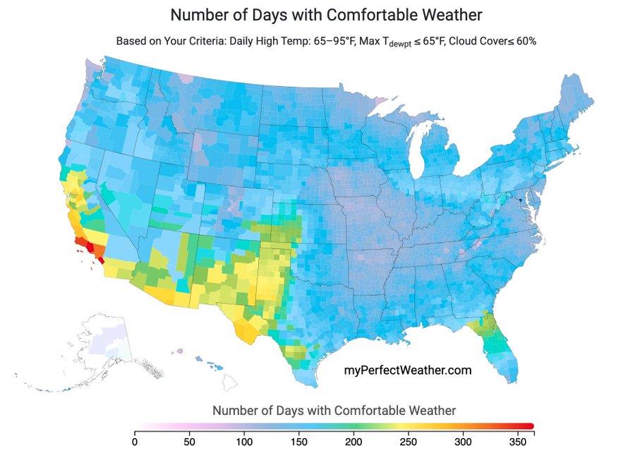
The honest version is much narrower than the popular version. Operational cloud seeding programs, which introduce silver iodide or similar ice nuclei into supercooled clouds from aircraft or ground generators, have been running in Wyoming since the 1950s, in Colorado since the 1970s, and across the western United States continuously. The Wyoming Weather Modification Program has been independently evaluated multiple times; the best current estimates put precipitation enhancement in target areas at roughly 5 to 15 percent in favorable conditions, with substantial uncertainty in individual storm events. That is a real effect. It is also a small effect, and it depends entirely on the pre-existing cloud conditions. Cloud seeding cannot create precipitation from clear skies. It works at the margin of an existing weather system.
The United Arab Emirates operates one of the most active national cloud seeding programs in the world, with over 1,000 missions per year by the UAE National Center of Meteorology. The program is real, operational, and technically sophisticated. Effect sizes for UAE operations are comparable to other documented programs: single-digit to low double-digit percent precipitation enhancement in target areas under favorable conditions. China’s Tianhe project aims to cover a target area roughly three times the size of Spain with cloud seeding infrastructure. The Chinese program is ambitious and well-funded. The underlying physical effect remains the same: marginal enhancement of precipitation where clouds are already present. These programs are demonstrated at the operational scale for which they are claimed.
What cloud seeding cannot do is equally important to state. It cannot steer tropical cyclones. It cannot manufacture precipitation from cloud-free air. It cannot produce regional climate change or modify seasonal precipitation patterns in any demonstrated way. The ontology anti-patterns include hurricane steering precisely because the popular imagination conflates localized weather modification with atmospheric control at a scale that no operational program has approached.
Urban cooling through albedo management, chiefly reflective roofs and pavements, shows cooling of 1 to 3 degrees Celsius at street level in treated areas on summer days. Los Angeles, Chicago, and New York have active programs. These are demonstrated at neighborhood scale. City-wide deployment is engineered: costs are estimable from existing programs. The effect does not extend beyond the treated urban area.
Snowpack augmentation is the most economically useful near-term form of localized weather modification. Snowpack is the principal water storage mechanism in the western United States, and modest enhancement in specific mountain watersheds carries compounding value as that water enters the downstream system over months. Colorado and Wyoming target this explicitly. The effect is real and operational, though precise attribution of any given season’s snowpack to seeding operations remains difficult to establish rigorously.
What this is not
Stratospheric aerosol injection, in which sulfate particles would be dispersed at high altitude to reduce incoming solar radiation globally, is a different category of intervention entirely. Its consequences would be distributed across the globe in ways no single actor can control or model with confidence. The risk profile, governance requirement, and physical mechanism all differ from territorial engineering. Mars terraforming is further still. Both are mentioned here as contrasts, not as extensions of this research program.
The substrate is a design variable
What connects coastline, elevation, inland hydrology, and localized weather modification is not a unified technology. The engineering approaches are entirely different. What they share is the conceptual move: treating the physical substrate of territory as a parameter, not a given.
Coastline is the most mature application of this logic. It has the clearest economic closure, the most developed industrial base, and the longest track record of demonstrated execution at scale. The roadmap covers what the next decade of coastline-focused work looks like. The financial models are in economics-and-value-capture. The permitting environment is in institutions-and-permitting.
The other wedges are at earlier stages of the same argument. Grade-raising is demonstrated in isolated applications but not at program scale in the United States. Interior hydrology has dramatic precedents, but the design discipline for useful new inland water at territorial planning scale is not yet codified. Localized weather modification is operational but confined to modest precipitation enhancement in favorable conditions, and no operational claim warrants more confidence than that.
The shape of the land, the vertical grade of coastal cities, the distribution of fresh water, and the precipitation that fills snowpack are all design variables at different stages of readiness. The appropriate response to that spread is not to collapse the distinctions but to work through each in turn.